Chanteau geodata
Chanteau (Centre) is a populated place; located in France in Europe/Paris (GMT+2) time zone. With population of 1,268 people, there are 7192 cities with bigger population in this country. Compared to other cities in France, 58.7% of cities are located further ↓South; 57.5% of cities are located further →East and 50.9% of cities have higher elevation than Chanteau. Note1
Administrative division(s):
- Level 1: Centre
- Level 2: Loiret
- Level 3: Arrondissement d’Orléans
- Level 4: Chanteau


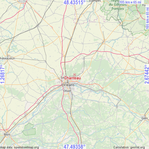
Chanteau GPS coordinates[2]
47° 57' 59.436" North, 1° 58' 16.644" East
| Map corner | latitude | longitude |
|---|---|---|
| Upper-left | 48.43515°, | 1.26817° |
| Center: | 47.96651°, | 1.97129° |
| Lower-right: | 47.49358°, | 2.67442° |
| Map W x H: | 104.7×104.7 km | = 65.1×65.1mi |
| max Lat: | 51.07786° ⇑41.3% North |
| Chanteau: | 47.96651° |
| min Lat: | ⇓58.7% South 41.3874° |
| min Long | Chanteau | max Long |
| -5.08615° | 1.97129° | 9.52242° |
| W 42.5%⇐ | ⇒57.5% E |
Elevation
Elevation of Chanteau is 129 m = 423 ft, and this is 64.7 m = 212 ft below average elevation for this country.
| Max E: |
2333 m = 7654 ft | 50.9% |
| Avg. | 193.7 m = 635 ft | |
| Chanteau | 129 m = 423 ft | |
Min E: |
-1 m = -3 ft | 49.1% |
See also: France elevation on elevation.city.
Geographical zone
Chanteau is located in North temperate zone (between Tropic of Cancer and the Arctic Circle). Distance of this North polar circle is 2067.8 km =1284.9 mi to North.| Distance of | km | miles | from Chanteau |
|---|---|---|---|
| North Pole | 4673.7 | 2904.1 | to North |
| Arctic Circle | 2067.8 | 1284.9 | to North |
| Tropic Cancer | 2727.5 | 1694.8 | to South |
| Equator | 5333.4 | 3314 | to South |


Nearby cities:
15 places around Chanteau: (largest is in red/bold)
• Boigny-sur-Bionne
5 km =3.1 mi,  137°
137°
• Cercottes
6.9 km =4.3 mi,  288°
288°
• Chécy
8.9 km =5.5 mi,  154°
154°
• Fleury-les-Aubrais
5.4 km =3.4 mi,  226°
226°
• Loury
9.2 km =5.7 mi,  66°
66°
• Marigny-les-Usages
3.4 km =2.1 mi,  106°
106°
• Orléans
8.7 km =5.4 mi,  215°
215°
• Rebréchien
5.9 km =3.7 mi, 66°
• Saint-Jean-de-Braye
6 km =3.7 mi,  175°
175°
• Saint-Jean-le-Blanc
9.1 km =5.7 mi,  207°
207°
• Saint-Lyé-la-Forêt
8.3 km =5.2 mi,  5°
5°
• Saran
7.3 km =4.5 mi,  255°
255°
• Semoy
4 km =2.5 mi,  203°
203°
• Traînou
9.9 km =6.2 mi,  85°
85°
• Vennecy
6.3 km =3.9 mi,  102°
102°
Sources, notices
• [Note1] Compared only with cities in France existing in our database
• [Src1] Map data: © OpenStreetMap contributors (CC-BY-SA)
• [Src2] Other city data from geonames.org with taken over terms of usage.
• [Src3] Geographical zone / Annual Mean Temperature by Robert A. Rohde @ Wikipedia
