Loury geodata
Loury (Centre) is a populated place; located in France in Europe/Paris (GMT+2) time zone. With population of 2,114 people, there are 4554 cities with bigger population in this country. Compared to other cities in France, 59.2% of cities are located further ↓South; 56% of cities are located further →East and 54.8% of cities have higher elevation than Loury. Note1
Administrative division(s):
- Level 1: Centre
- Level 2: Loiret
- Level 3: Arrondissement d’Orléans
- Level 4: Loury


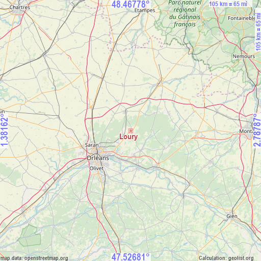
Loury GPS coordinates[2]
47° 59' 57.984" North, 2° 5' 5.064" East
| Map corner | latitude | longitude |
|---|---|---|
| Upper-left | 48.46778°, | 1.38162° |
| Center: | 47.99944°, | 2.08474° |
| Lower-right: | 47.52681°, | 2.78787° |
| Map W x H: | 104.6×104.6 km | = 65×65mi |
| max Lat: | 51.07786° ⇑40.8% North |
| Loury: | 47.99944° |
| min Lat: | ⇓59.2% South 41.3874° |
| min Long | Loury | max Long |
| -5.08615° | 2.08474° | 9.52242° |
| W 44%⇐ | ⇒56% E |
Elevation
Elevation of Loury is 117 m = 384 ft, and this is 76.7 m = 252 ft below average elevation for this country.
| Max E: |
2333 m = 7654 ft | 54.8% |
| Avg. | 193.7 m = 635 ft | |
| Loury | 117 m = 384 ft | |
Min E: |
-1 m = -3 ft | 45.2% |
See also: France elevation on elevation.city.
Geographical zone
Loury is located in North temperate zone (between Tropic of Cancer and the Arctic Circle). Distance of this North polar circle is 2064.1 km =1282.6 mi to North.| Distance of | km | miles | from Loury |
|---|---|---|---|
| North Pole | 4670 | 2901.8 | to North |
| Arctic Circle | 2064.1 | 1282.6 | to North |
| Tropic Cancer | 2731.1 | 1697 | to South |
| Equator | 5337 | 3316.3 | to South |


Nearby cities:
15 places around Loury: (largest is in red/bold)
• Boigny-sur-Bionne
8.9 km =5.5 mi,  214°
214°
• Chanteau
9.2 km =5.7 mi,  246°
246°
• Chilleurs-aux-Bois
8.9 km =5.5 mi,  24°
24°
• Chécy
12.6 km =7.8 mi,  201°
201°
• Donnery
9.5 km =5.9 mi,  171°
171°
• Fay-aux-Loges
9 km =5.6 mi,  152°
152°
• Marigny-les-Usages
7 km =4.3 mi,  228°
228°
• Neuville-aux-Bois
8 km =5 mi,  343°
343°
• Puiseaux
10.5 km =6.5 mi,  349°
349°
• Rebréchien
3.3 km =2.1 mi, 245°
• Saint-Jean-de-Braye
12.5 km =7.8 mi,  219°
219°
• Saint-Lyé-la-Forêt
8.9 km =5.5 mi,  301°
301°
• Semoy
12.4 km =7.7 mi, 233°
• Traînou
3.2 km =2 mi, 153°
• Vennecy
5.5 km =3.4 mi, 204°
Sources, notices
• [Note1] Compared only with cities in France existing in our database
• [Src1] Map data: © OpenStreetMap contributors (CC-BY-SA)
• [Src2] Other city data from geonames.org with taken over terms of usage.
• [Src3] Geographical zone / Annual Mean Temperature by Robert A. Rohde @ Wikipedia
