Saint-Lyé-la-Forêt geodata
Saint-Lyé-la-Forêt (Centre) is a populated place; located in France in Europe/Paris (GMT+2) time zone. With population of 982 people, there are 8971 cities with bigger population in this country. Compared to other cities in France, 60% of cities are located further ↓South; 57.3% of cities are located further →East and 52% of cities have higher elevation than Saint-Lyé-la-Forêt. Note1
Administrative division(s):
- Level 1: Centre
- Level 2: Loiret
- Level 3: Arrondissement d’Orléans
- Level 4: Saint-Lyé-la-Forêt


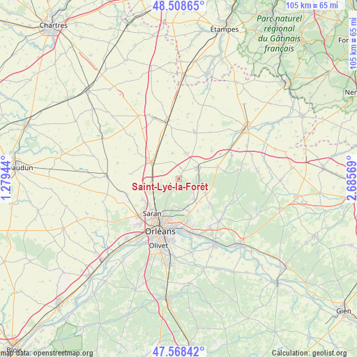
Saint-Lyé-la-Forêt GPS coordinates[2]
48° 2' 26.448" North, 1° 58' 57.216" East
| Map corner | latitude | longitude |
|---|---|---|
| Upper-left | 48.50865°, | 1.27944° |
| Center: | 48.04068°, | 1.98256° |
| Lower-right: | 47.56842°, | 2.68569° |
| Map W x H: | 104.5×104.5 km | = 64.9×64.9mi |
| max Lat: | 51.07786° ⇑40% North |
| Saint-Lyé-la-Forêt: | 48.04068° |
| min Lat: | ⇓60% South 41.3874° |
| min Long | Saint-Lyé-la-F | max Long |
| -5.08615° | 1.98256° | 9.52242° |
| W 42.7%⇐ | ⇒57.3% E |
Elevation
Elevation of Saint-Lyé-la-Forêt is 125 m = 410 ft, and this is 68.7 m = 225 ft below average elevation for this country.
| Max E: |
2333 m = 7654 ft | 52% |
| Avg. | 193.7 m = 635 ft | |
| Saint-Lyé-la-Forêt | 125 m = 410 ft | |
Min E: |
-1 m = -3 ft | 48% |
See also: France elevation on elevation.city.
Geographical zone
Saint-Lyé-la-Forêt is located in North temperate zone (between Tropic of Cancer and the Arctic Circle). Distance of this North polar circle is 2059.6 km =1279.8 mi to North.| Distance of | km | miles | from Saint-Lyé-la-Forêt |
|---|---|---|---|
| North Pole | 4665.4 | 2898.9 | to North |
| Arctic Circle | 2059.6 | 1279.8 | to North |
| Tropic Cancer | 2735.7 | 1699.9 | to South |
| Equator | 5341.6 | 3319.1 | to South |


Nearby cities:
15 places around Saint-Lyé-la-Forêt: (largest is in red/bold)
• Artenay
8.9 km =5.5 mi,  301°
301°
• Aschères-le-Marché
7.9 km =4.9 mi,  13°
13°
• Boigny-sur-Bionne
12.2 km =7.6 mi,  167°
167°
• Cercottes
9.5 km =5.9 mi,  230°
230°
• Chanteau
8.3 km =5.2 mi,  185°
185°
• Chevilly
8.2 km =5.1 mi,  261°
261°
• Chilleurs-aux-Bois
11.9 km =7.4 mi,  72°
72°
• Loury
8.9 km =5.5 mi,  121°
121°
• Marigny-les-Usages
9.5 km =5.9 mi, 165°
• Neuville-aux-Bois
6.1 km =3.8 mi,  60°
60°
• Puiseaux
8.1 km =5 mi,  44°
44°
• Rebréchien
7.5 km =4.7 mi,  142°
142°
• Semoy
12.2 km =7.6 mi, 191°
• Traînou
11.7 km =7.3 mi,  129°
129°
• Vennecy
11 km =6.8 mi,  150°
150°
Sources, notices
• [Note1] Compared only with cities in France existing in our database
• [Src1] Map data: © OpenStreetMap contributors (CC-BY-SA)
• [Src2] Other city data from geonames.org with taken over terms of usage.
• [Src3] Geographical zone / Annual Mean Temperature by Robert A. Rohde @ Wikipedia
