Champagnac geodata
Champagnac (Nouvelle-Aquitaine) is a populated place; located in France in Europe/Paris (GMT+2) time zone. With population of 502 people, there are 15200 cities with bigger population in this country. Compared to other cities in France, 75% of cities are located further ↑North; 81.8% of cities are located further →East and 81.5% of cities have higher elevation than Champagnac. Note1
Administrative division(s):
- Level 1: Nouvelle-Aquitaine
- Level 2: Charente-Maritime
- Level 3: Arrondissement de Jonzac
- Level 4: Champagnac


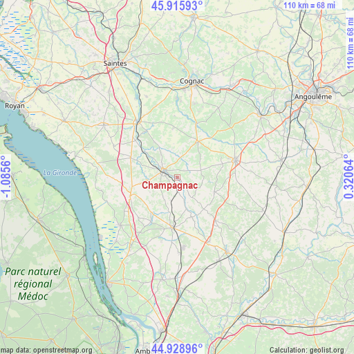
Champagnac GPS coordinates[2]
45° 25' 28.56" North, 0° 22' 56.928" West
| Map corner | latitude | longitude |
|---|---|---|
| Upper-left | 45.91593°, | -1.0856° |
| Center: | 45.4246°, | -0.38248° |
| Lower-right: | 44.92896°, | 0.32064° |
| Map W x H: | 109.7×109.7 km | = 68.2×68.2mi |
| max Lat: | 51.07786° ⇑75% North |
| Champagnac: | 45.4246° |
| min Lat: | ⇓25% South 41.3874° |
| min Long | Champagnac | max Long |
| -5.08615° | -0.38248° | 9.52242° |
| W 18.2%⇐ | ⇒81.8% E |
Elevation
Elevation of Champagnac is 51 m = 167 ft, and this is 142.7 m = 468 ft below average elevation for this country.
| Max E: |
2333 m = 7654 ft | 81.5% |
| Avg. | 193.7 m = 635 ft | |
| Champagnac | 51 m = 167 ft | |
Min E: |
-1 m = -3 ft | 18.5% |
See also: France elevation on elevation.city.
Geographical zone
Champagnac is located in North temperate zone (between Tropic of Cancer and the Arctic Circle). Distance of this North polar circle is 2350.4 km =1460.5 mi to North.| Distance of | km | miles | from Champagnac |
|---|---|---|---|
| North Pole | 4956.3 | 3079.7 | to North |
| Arctic Circle | 2350.4 | 1460.5 | to North |
| Tropic Cancer | 2444.8 | 1519.1 | to South |
| Equator | 5050.7 | 3138.4 | to South |


Nearby cities:
15 places around Champagnac: (largest is in red/bold)
• Archiac
12.1 km =7.5 mi,  32°
32°
• Baignes-Sainte-Radegonde
12.5 km =7.8 mi,  111°
111°
• Barret
15.7 km =9.8 mi,  65°
65°
• Clion
11 km =6.8 mi,  303°
303°
• Guimps
11.3 km =7 mi, 65°
• Jarnac-Champagne
15.1 km =9.4 mi,  354°
354°
• Jonzac
4.7 km =2.9 mi, 301°
• Montchaude
14.5 km =9 mi,  78°
78°
• Nieul-le-Virouil
11.7 km =7.3 mi,  261°
261°
• Ozillac
3.6 km =2.2 mi,  193°
193°
• Réaux
5.9 km =3.7 mi,  6°
6°
• Saint-Germain-de-Lusignan
6.8 km =4.2 mi,  294°
294°
• Saint-Maigrin
7.8 km =4.8 mi,  96°
96°
• Saint-Simon-de-Bordes
6.5 km =4 mi,  240°
240°
• Touvérac
15 km =9.3 mi, 107°
Sources, notices
• [Note1] Compared only with cities in France existing in our database
• [Src1] Map data: © OpenStreetMap contributors (CC-BY-SA)
• [Src2] Other city data from geonames.org with taken over terms of usage.
• [Src3] Geographical zone / Annual Mean Temperature by Robert A. Rohde @ Wikipedia
