Clion geodata
Clion (Nouvelle-Aquitaine) is a populated place; located in France in Europe/Paris (GMT+2) time zone. With population of 784 people, there are 10781 cities with bigger population in this country. Compared to other cities in France, 74.4% of cities are located further ↑North; 83.4% of cities are located further →East and 89.9% of cities have higher elevation than Clion. Note1
Administrative division(s):
- Level 1: Nouvelle-Aquitaine
- Level 2: Charente-Maritime
- Level 3: Arrondissement de Jonzac
- Level 4: Clion


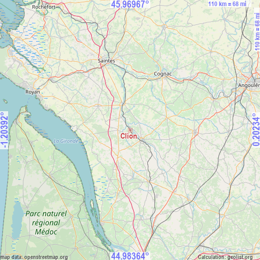
Clion GPS coordinates[2]
45° 28' 43.716" North, 0° 30' 2.844" West
| Map corner | latitude | longitude |
|---|---|---|
| Upper-left | 45.96967°, | -1.20392° |
| Center: | 45.47881°, | -0.50079° |
| Lower-right: | 44.98364°, | 0.20234° |
| Map W x H: | 109.6×109.6 km | = 68.1×68.1mi |
| max Lat: | 51.07786° ⇑74.4% North |
| Clion: | 45.47881° |
| min Lat: | ⇓25.6% South 41.3874° |
| min Long | Clion | max Long |
| -5.08615° | -0.50079° | 9.52242° |
| W 16.6%⇐ | ⇒83.4% E |
Elevation
Elevation of Clion is 30 m = 98 ft, and this is 163.7 m = 537 ft below average elevation for this country.
| Max E: |
2333 m = 7654 ft | 89.9% |
| Avg. | 193.7 m = 635 ft | |
| Clion | 30 m = 98 ft | |
Min E: |
-1 m = -3 ft | 10.1% |
See also: France elevation on elevation.city.
Geographical zone
Clion is located in North temperate zone (between Tropic of Cancer and the Arctic Circle). Distance of this North polar circle is 2344.4 km =1456.7 mi to North.| Distance of | km | miles | from Clion |
|---|---|---|---|
| North Pole | 4950.3 | 3076 | to North |
| Arctic Circle | 2344.4 | 1456.7 | to North |
| Tropic Cancer | 2450.9 | 1522.9 | to South |
| Equator | 5056.8 | 3142.1 | to South |


Nearby cities:
15 places around Clion: (largest is in red/bold)
• Archiac
16.2 km =10.1 mi,  74°
74°
• Avy
8.2 km =5.1 mi,  356°
356°
• Champagnac
11 km =6.8 mi,  123°
123°
• Champagnolles
11.2 km =7 mi,  289°
289°
• Jarnac-Champagne
11.9 km =7.4 mi,  41°
41°
• Jonzac
6.3 km =3.9 mi, 124°
• Mirambeau
13 km =8.1 mi,  204°
204°
• Nieul-le-Virouil
8.1 km =5 mi, 196°
• Ozillac
12.6 km =7.8 mi,  138°
138°
• Pons
11.8 km =7.3 mi,  341°
341°
• Réaux
9.9 km =6.2 mi,  90°
90°
• Saint-Ciers-du-Taillon
12.5 km =7.8 mi,  240°
240°
• Saint-Genis-de-Saintonge
5.3 km =3.3 mi,  272°
272°
• Saint-Germain-de-Lusignan
4.4 km =2.7 mi, 136°
• Saint-Simon-de-Bordes
9.9 km =6.2 mi,  158°
158°
Sources, notices
• [Note1] Compared only with cities in France existing in our database
• [Src1] Map data: © OpenStreetMap contributors (CC-BY-SA)
• [Src2] Other city data from geonames.org with taken over terms of usage.
• [Src3] Geographical zone / Annual Mean Temperature by Robert A. Rohde @ Wikipedia
