Chalon-sur-Saône geodata
Chalon-sur-Saône (Bourgogne-Franche-Comté) is a seat of a third-order administrative division; located in France in Europe/Paris (GMT+2) time zone. With population of 47,251 people, there are 135 cities with bigger population in this country. Compared to other cities in France, 57.4% of cities are located further ↑North; 75.9% of cities are located further ←West and 61% of cities have lower elevation than Chalon-sur-Saône. Note1
Administrative division(s):
- Level 1: Bourgogne-Franche-Comté
- Level 2: Département de Saône-et-Loire
- Level 3: Arrondissement de Chalon-sur-Saône
- Level 4: Chalon-sur-Saône


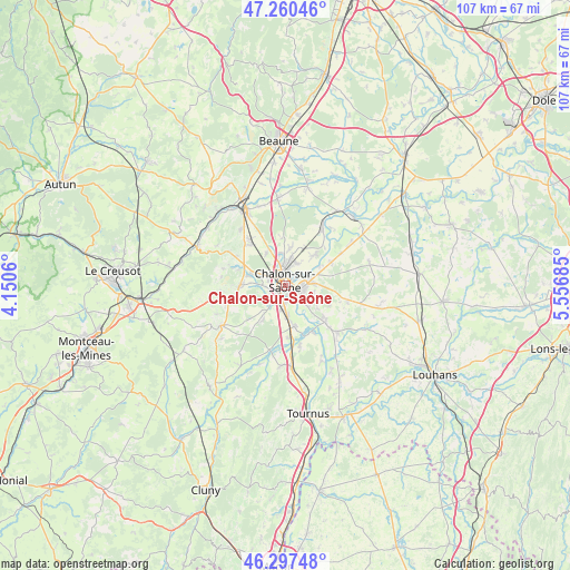
Chalon-sur-Saône GPS coordinates[2]
46° 46' 52.032" North, 4° 51' 13.392" East
| Map corner | latitude | longitude |
|---|---|---|
| Upper-left | 47.26046°, | 4.1506° |
| Center: | 46.78112°, | 4.85372° |
| Lower-right: | 46.29748°, | 5.55685° |
| Map W x H: | 107.1×107.1 km | = 66.5×66.5mi |
| max Lat: | 51.07786° ⇑57.4% North |
| Chalon-sur-Saône: | 46.78112° |
| min Lat: | ⇓42.6% South 41.3874° |
| min Long | Chalon-sur-Saô | max Long |
| -5.08615° | 4.85372° | 9.52242° |
| W 75.9%⇐ | ⇒24.1% E |
Elevation
Elevation of Chalon-sur-Saône is 175 m = 574 ft, and this is 18.7 m = 61 ft below average elevation for this country.
| Max E: |
2333 m = 7654 ft | 39% |
| Avg. | 193.7 m = 635 ft | |
| Chalon-sur-Saône | 175 m = 574 ft | |
Min E: |
-1 m = -3 ft | 61% |
See also: Chalon-sur-Saône elevation on elevation.city.
Geographical zone
Chalon-sur-Saône is located in North temperate zone (between Tropic of Cancer and the Arctic Circle). Distance of this North polar circle is 2199.6 km =1366.8 mi to North.| Distance of | km | miles | from Chalon-sur-Saône |
|---|---|---|---|
| North Pole | 4805.5 | 2986 | to North |
| Arctic Circle | 2199.6 | 1366.8 | to North |
| Tropic Cancer | 2595.7 | 1612.9 | to South |
| Equator | 5201.6 | 3232.1 | to South |


Nearby cities:
15 places around Chalon-sur-Saône: (largest is in red/bold)
• Champforgeuil
4.4 km =2.7 mi,  339°
339°
• Châtenoy-en-Bresse
4.6 km =2.9 mi,  75°
75°
• Châtenoy-le-Royal
3.7 km =2.3 mi,  300°
300°
• Crissey
4.5 km =2.8 mi,  28°
28°
• Dracy-le-Fort
7.2 km =4.5 mi,  284°
284°
• Farges-lès-Chalon
6.8 km =4.2 mi,  329°
329°
• Fragnes
6.1 km =3.8 mi,  353°
353°
• Lans
5.3 km =3.3 mi,  103°
103°
• Oslon
5.3 km =3.3 mi,  86°
86°
• Saint-Marcel
3 km =1.9 mi,  105°
105°
• Saint-Rémy
2.3 km =1.4 mi,  209°
209°
• Sevrey
4.9 km =3 mi,  192°
192°
• Varennes-le-Grand
7 km =4.3 mi,  170°
170°
• Virey-le-Grand
5.9 km =3.7 mi,  9°
9°
• Épervans
4.7 km =2.9 mi,  132°
132°
Sources, notices
• [Note1] Compared only with cities in France existing in our database
• [Src1] Map data: © OpenStreetMap contributors (CC-BY-SA)
• [Src2] Other city data from geonames.org with taken over terms of usage.
• [Src3] Geographical zone / Annual Mean Temperature by Robert A. Rohde @ Wikipedia
