Castries geodata
Castries (Occitanie) is a populated place; located in France in Europe/Paris (GMT+2) time zone. With population of 5,790 people, there are 1704 cities with bigger population in this country. Compared to other cities in France, 90.8% of cities are located further ↑North; 67.6% of cities are located further ←West and 72.6% of cities have higher elevation than Castries. Note1
Administrative division(s):
- Level 1: Occitanie
- Level 2: Département de l'Hérault
- Level 3: Arrondissement of Montpellier
- Level 4: Castries


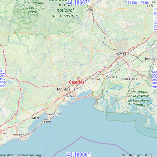
Castries GPS coordinates[2]
43° 40' 46.992" North, 3° 58' 55.992" East
| Map corner | latitude | longitude |
|---|---|---|
| Upper-left | 44.18607°, | 3.2791° |
| Center: | 43.67972°, | 3.98222° |
| Lower-right: | 43.16906°, | 4.68535° |
| Map W x H: | 113.1×113.1 km | = 70.3×70.3mi |
| max Lat: | 51.07786° ⇑90.8% North |
| Castries: | 43.67972° |
| min Lat: | ⇓9.2% South 41.3874° |
| min Long | Castries | max Long |
| -5.08615° | 3.98222° | 9.52242° |
| W 67.6%⇐ | ⇒32.4% E |
Elevation
Elevation of Castries is 72 m = 236 ft, and this is 121.7 m = 399 ft below average elevation for this country.
| Max E: |
2333 m = 7654 ft | 72.6% |
| Avg. | 193.7 m = 635 ft | |
| Castries | 72 m = 236 ft | |
Min E: |
-1 m = -3 ft | 27.4% |
See also: France elevation on elevation.city.
Geographical zone
Castries is located in North temperate zone (between Tropic of Cancer and the Arctic Circle). Distance of this Northern Tropic circle is 2250.8 km =1398.6 mi to South.| Distance of | km | miles | from Castries |
|---|---|---|---|
| North Pole | 5150.3 | 3200.2 | to North |
| Arctic Circle | 2544.4 | 1581 | to North |
| Tropic Cancer | 2250.8 | 1398.6 | to South |
| Equator | 4856.7 | 3017.8 | to South |


Nearby cities:
15 places around Castries: (largest is in red/bold)
• Baillargues
3.4 km =2.1 mi,  124°
124°
• Beaulieu
6.3 km =3.9 mi,  30°
30°
• Jacou
6 km =3.7 mi,  250°
250°
• Le Crès
4.9 km =3 mi,  224°
224°
• Mauguio
7.1 km =4.4 mi,  163°
163°
• Mudaison
6.6 km =4.1 mi,  141°
141°
• Restinclières
6.4 km =4 mi,  41°
41°
• Saint-Aunès
4.5 km =2.8 mi,  196°
196°
• Saint-Brès
4.2 km =2.6 mi,  109°
109°
• Saint-Drézéry
5.6 km =3.5 mi,  355°
355°
• Saint-Geniès-des-Mourgues
4.8 km =3 mi,  65°
65°
• Sussargues
4 km =2.5 mi,  24°
24°
• Teyran
4.3 km =2.7 mi,  278°
278°
• Valergues
6.5 km =4 mi,  101°
101°
• Vendargues
2.6 km =1.6 mi, 202°
Sources, notices
• [Note1] Compared only with cities in France existing in our database
• [Src1] Map data: © OpenStreetMap contributors (CC-BY-SA)
• [Src2] Other city data from geonames.org with taken over terms of usage.
• [Src3] Geographical zone / Annual Mean Temperature by Robert A. Rohde @ Wikipedia
