Saint-Geniès-des-Mourgues geodata
Saint-Geniès-des-Mourgues (Occitanie) is a populated place; located in France in Europe/Paris (GMT+2) time zone. With population of 1,699 people, there are 5524 cities with bigger population in this country. Compared to other cities in France, 90.5% of cities are located further ↑North; 68.2% of cities are located further ←West and 75% of cities have higher elevation than Saint-Geniès-des-Mourgues. Note1
Administrative division(s):
- Level 1: Occitanie
- Level 2: Département de l'Hérault
- Level 3: Arrondissement of Montpellier
- Level 4: Saint-Geniès-des-Mourgues
Current local time in Saint-Geniès-des-Mourgues:
01:44 PM, WednesdayDifference from your time zone: hours


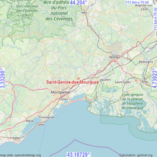
Saint-Geniès-des-Mourgues GPS coordinates[2]
43° 41' 52.08" North, 4° 2' 9.96" East
| Map corner | latitude | longitude |
|---|---|---|
| Upper-left | 44.204°, | 3.33298° |
| Center: | 43.6978°, | 4.0361° |
| Lower-right: | 43.18729°, | 4.73923° |
| Map W x H: | 113×113 km | = 70.2×70.2mi |
| max Lat: | 51.07786° ⇑90.5% North |
| Saint-Geniès-des-Mourgues: | 43.6978° |
| min Lat: | ⇓9.5% South 41.3874° |
| min Long | Saint-Geniès-d | max Long |
| -5.08615° | 4.0361° | 9.52242° |
| W 68.2%⇐ | ⇒31.8% E |
Elevation
Elevation of Saint-Geniès-des-Mourgues is 67 m = 220 ft, and this is 126.7 m = 416 ft below average elevation for this country.
| Max E: |
2333 m = 7654 ft | 75% |
| Avg. | 193.7 m = 635 ft | |
| Saint-Geniès-des-Mourgues | 67 m = 220 ft | |
Min E: |
-1 m = -3 ft | 25% |
See also: France elevation on elevation.city.
Geographical zone
Saint-Geniès-des-Mourgues is located in North temperate zone (between Tropic of Cancer and the Arctic Circle). Distance of this Northern Tropic circle is 2252.8 km =1399.8 mi to South.| Distance of | km | miles | from Saint-Geniès-des-Mourgues |
|---|---|---|---|
| North Pole | 5148.3 | 3199 | to North |
| Arctic Circle | 2542.4 | 1579.8 | to North |
| Tropic Cancer | 2252.8 | 1399.8 | to South |
| Equator | 4858.7 | 3019.1 | to South |


Nearby cities:
15 places around Saint-Geniès-des-Mourgues: (largest is in red/bold)
• Baillargues
4.2 km =2.6 mi,  201°
201°
• Beaulieu
3.6 km =2.2 mi,  341°
341°
• Castries
4.8 km =3 mi,  245°
245°
• Lansargues
6 km =3.7 mi,  148°
148°
• Lunel-Viel
5 km =3.1 mi,  114°
114°
• Restinclières
2.8 km =1.7 mi,  357°
357°
• Saint-Brès
3.4 km =2.1 mi,  186°
186°
• Saint-Christol
4.9 km =3 mi,  46°
46°
• Saint-Drézéry
6 km =3.7 mi,  306°
306°
• Saint-Jean-de-Cornies
5.9 km =3.7 mi,  332°
332°
• Saint-Sériès
6.5 km =4 mi, 52°
• Saturargues
6.8 km =4.2 mi,  66°
66°
• Sussargues
3.1 km =1.9 mi,  301°
301°
• Valergues
3.9 km =2.4 mi, 148°
• Vérargues
5.5 km =3.4 mi, 67°
Sources, notices
• [Note1] Compared only with cities in France existing in our database
• [Src1] Map data: © OpenStreetMap contributors (CC-BY-SA)
• [Src2] Other city data from geonames.org with taken over terms of usage.
• [Src3] Geographical zone / Annual Mean Temperature by Robert A. Rohde @ Wikipedia
