Carentan geodata
Carentan (Normandy) is a populated place; located in France in Europe/Paris (GMT+2) time zone. With population of 6,950 people, there are 1420 cities with bigger population in this country. Compared to other cities in France, 86.2% of cities are located further ↓South; 90.4% of cities are located further →East and 98.2% of cities have higher elevation than Carentan. Note1
Administrative division(s):
- Level 1: Normandy
- Level 2: Manche
- Level 3: Arrondissement de Saint-Lô
- Level 4: Carentan-les-Marais


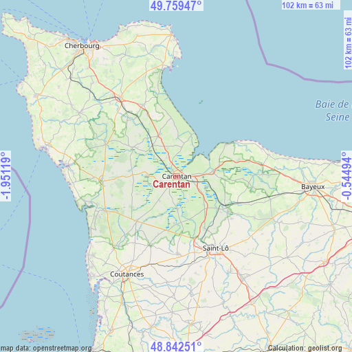
Carentan GPS coordinates[2]
49° 18' 11.232" North, 1° 14' 53.016" West
| Map corner | latitude | longitude |
|---|---|---|
| Upper-left | 49.75947°, | -1.95119° |
| Center: | 49.30312°, | -1.24806° |
| Lower-right: | 48.84251°, | -0.54494° |
| Map W x H: | 102×102 km | = 63.4×63.4mi |
| max Lat: | 51.07786° ⇑13.8% North |
| Carentan: | 49.30312° |
| min Lat: | ⇓86.2% South 41.3874° |
| min Long | Carentan | max Long |
| -5.08615° | -1.24806° | 9.52242° |
| W 9.6%⇐ | ⇒90.4% E |
Elevation
Elevation of Carentan is 8 m = 26 ft, and this is 185.7 m = 609 ft below average elevation for this country.
| Max E: |
2333 m = 7654 ft | 98.2% |
| Avg. | 193.7 m = 635 ft | |
| Carentan | 8 m = 26 ft | |
Min E: |
-1 m = -3 ft | 1.8% |
See also: France elevation on elevation.city.
Geographical zone
Carentan is located in North temperate zone (between Tropic of Cancer and the Arctic Circle). Distance of this North polar circle is 1919.2 km =1192.5 mi to North.| Distance of | km | miles | from Carentan |
|---|---|---|---|
| North Pole | 4525.1 | 2811.8 | to North |
| Arctic Circle | 1919.2 | 1192.5 | to North |
| Tropic Cancer | 2876.1 | 1787.1 | to South |
| Equator | 5482 | 3406.4 | to South |


Nearby cities:
15 places around Carentan: (largest is in red/bold)
• Auvers
5.3 km =3.3 mi,  265°
265°
• Chef-du-Pont
11.4 km =7.1 mi,  322°
322°
• Graignes-Mesnil-Angot
6.9 km =4.3 mi,  149°
149°
• Isigny-sur-Mer
10.6 km =6.6 mi,  82°
82°
• Le Dézert
12.6 km =7.8 mi, 151°
• Marchésieux
13.1 km =8.1 mi,  193°
193°
• Montmartin-en-Graignes
7.9 km =4.9 mi,  113°
113°
• Méautis
4.7 km =2.9 mi,  232°
232°
• Osmanville
12.5 km =7.8 mi, 76°
• Saint-Hilaire-Petitville
2 km =1.2 mi,  91°
91°
• Saint-Jean-de-Daye
11.6 km =7.2 mi,  135°
135°
• Sainte-Marie-du-Mont
8.6 km =5.3 mi,  10°
10°
• Sainte-Mère-Église
12.9 km =8 mi,  337°
337°
• Sainteny
8.7 km =5.4 mi,  213°
213°
• Tribehou
10.1 km =6.3 mi,  178°
178°
Sources, notices
• [Note1] Compared only with cities in France existing in our database
• [Src1] Map data: © OpenStreetMap contributors (CC-BY-SA)
• [Src2] Other city data from geonames.org with taken over terms of usage.
• [Src3] Geographical zone / Annual Mean Temperature by Robert A. Rohde @ Wikipedia
