Chef-du-Pont geodata
Chef-du-Pont (Normandy) is a populated place; located in France in Europe/Paris (GMT+2) time zone. With population of 769 people, there are 10958 cities with bigger population in this country. Compared to other cities in France, 87.6% of cities are located further ↓South; 91.1% of cities are located further →East and 98.2% of cities have higher elevation than Chef-du-Pont. Note1
Administrative division(s):
- Level 1: Normandy
- Level 2: Manche
- Level 3: Arrondissement de Cherbourg
- Level 4: Sainte-Mère-Église


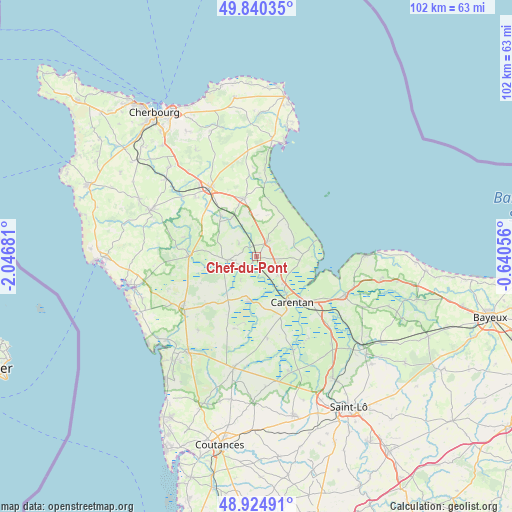
Chef-du-Pont GPS coordinates[2]
49° 23' 5.136" North, 1° 20' 37.248" West
| Map corner | latitude | longitude |
|---|---|---|
| Upper-left | 49.84035°, | -2.04681° |
| Center: | 49.38476°, | -1.34368° |
| Lower-right: | 48.92491°, | -0.64056° |
| Map W x H: | 101.8×101.8 km | = 63.3×63.3mi |
| max Lat: | 51.07786° ⇑12.4% North |
| Chef-du-Pont: | 49.38476° |
| min Lat: | ⇓87.6% South 41.3874° |
| min Long | Chef-du-Pont | max Long |
| -5.08615° | -1.34368° | 9.52242° |
| W 8.9%⇐ | ⇒91.1% E |
Elevation
Elevation of Chef-du-Pont is 8 m = 26 ft, and this is 185.7 m = 609 ft below average elevation for this country.
| Max E: |
2333 m = 7654 ft | 98.2% |
| Avg. | 193.7 m = 635 ft | |
| Chef-du-Pont | 8 m = 26 ft | |
Min E: |
-1 m = -3 ft | 1.8% |
See also: France elevation on elevation.city.
Geographical zone
Chef-du-Pont is located in North temperate zone (between Tropic of Cancer and the Arctic Circle). Distance of this North polar circle is 1910.1 km =1186.9 mi to North.| Distance of | km | miles | from Chef-du-Pont |
|---|---|---|---|
| North Pole | 4516 | 2806.1 | to North |
| Arctic Circle | 1910.1 | 1186.9 | to North |
| Tropic Cancer | 2885.2 | 1792.8 | to South |
| Equator | 5491.1 | 3412 | to South |


Nearby cities:
15 places around Chef-du-Pont: (largest is in red/bold)
• Auvers
9.7 km =6 mi,  170°
170°
• Carentan
11.4 km =7.1 mi,  142°
142°
• Graignes-Mesnil-Angot
18.2 km =11.3 mi,  145°
145°
• La Haye-du-Puits
17.9 km =11.1 mi,  233°
233°
• Lithaire
13.9 km =8.6 mi, 226°
• Montebourg
11.8 km =7.3 mi,  346°
346°
• Méautis
12.3 km =7.6 mi,  164°
164°
• Picauville
4.2 km =2.6 mi,  259°
259°
• Saint-Hilaire-Petitville
12.8 km =8 mi, 135°
• Saint-Sauveur-le-Vicomte
13.7 km =8.5 mi,  270°
270°
• Sainte-Marie-du-Mont
8.6 km =5.3 mi,  94°
94°
• Sainte-Mère-Église
3.4 km =2.1 mi,  34°
34°
• Sainteny
16.4 km =10.2 mi, 172°
• Tamerville
18.2 km =11.3 mi,  334°
334°
• Valognes
16.6 km =10.3 mi, 326°
Sources, notices
• [Note1] Compared only with cities in France existing in our database
• [Src1] Map data: © OpenStreetMap contributors (CC-BY-SA)
• [Src2] Other city data from geonames.org with taken over terms of usage.
• [Src3] Geographical zone / Annual Mean Temperature by Robert A. Rohde @ Wikipedia
