Camblanes-et-Meynac geodata
Camblanes-et-Meynac (Nouvelle-Aquitaine) is a populated place; located in France in Europe/Paris (GMT+2) time zone. With population of 2,430 people, there are 3984 cities with bigger population in this country. Compared to other cities in France, 81.7% of cities are located further ↑North; 83.2% of cities are located further →East and 83.4% of cities have higher elevation than Camblanes-et-Meynac. Note1
Administrative division(s):
- Level 1: Nouvelle-Aquitaine
- Level 2: Gironde
- Level 3: Arrondissement de Bordeaux
- Level 4: Camblanes-et-Meynac


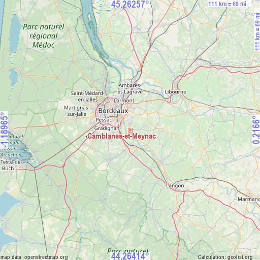
Camblanes-et-Meynac GPS coordinates[2]
44° 45' 55.836" North, 0° 29' 11.508" West
| Map corner | latitude | longitude |
|---|---|---|
| Upper-left | 45.26257°, | -1.18965° |
| Center: | 44.76551°, | -0.48653° |
| Lower-right: | 44.26414°, | 0.2166° |
| Map W x H: | 111×111 km | = 69×69mi |
| max Lat: | 51.07786° ⇑81.7% North |
| Camblanes-et-Meynac: | 44.76551° |
| min Lat: | ⇓18.3% South 41.3874° |
| min Long | Camblanes-et-Me | max Long |
| -5.08615° | -0.48653° | 9.52242° |
| W 16.8%⇐ | ⇒83.2% E |
Elevation
Elevation of Camblanes-et-Meynac is 46 m = 151 ft, and this is 147.7 m = 485 ft below average elevation for this country.
| Max E: |
2333 m = 7654 ft | 83.4% |
| Avg. | 193.7 m = 635 ft | |
| Camblanes-et-Meynac | 46 m = 151 ft | |
Min E: |
-1 m = -3 ft | 16.6% |
See also: France elevation on elevation.city.
Geographical zone
Camblanes-et-Meynac is located in North temperate zone (between Tropic of Cancer and the Arctic Circle). Distance of this Northern Tropic circle is 2371.5 km =1473.6 mi to South.| Distance of | km | miles | from Camblanes-et-Meynac |
|---|---|---|---|
| North Pole | 5029.6 | 3125.2 | to North |
| Arctic Circle | 2423.7 | 1506 | to North |
| Tropic Cancer | 2371.5 | 1473.6 | to South |
| Equator | 4977.5 | 3092.9 | to South |


Nearby cities:
15 places around Camblanes-et-Meynac: (largest is in red/bold)
• Ayguemorte-les-Graves
6.2 km =3.9 mi,  175°
175°
• Baurech
5.8 km =3.6 mi,  139°
139°
• Bouliac
5.9 km =3.7 mi,  347°
347°
• Cadaujac
3.7 km =2.3 mi,  250°
250°
• Cambes
4.2 km =2.6 mi,  153°
153°
• Carignan-de-Bordeaux
3.8 km =2.4 mi,  3°
3°
• Cénac
2.6 km =1.6 mi,  52°
52°
• Isle-Saint-Georges
4.6 km =2.9 mi,  166°
166°
• Latresne
2.3 km =1.4 mi, 353°
• Lignan-de-Bordeaux
5.8 km =3.6 mi, 53°
• Quinsac
1.1 km =0.7 mi, 181°
• Sadirac
6.1 km =3.8 mi,  72°
72°
• Saint-Caprais-de-Bordeaux
4.7 km =2.9 mi,  114°
114°
• Saint-Médard-d’Eyrans
5.9 km =3.7 mi,  203°
203°
• Villenave-d’Ornon
4.6 km =2.9 mi,  280°
280°
Sources, notices
• [Note1] Compared only with cities in France existing in our database
• [Src1] Map data: © OpenStreetMap contributors (CC-BY-SA)
• [Src2] Other city data from geonames.org with taken over terms of usage.
• [Src3] Geographical zone / Annual Mean Temperature by Robert A. Rohde @ Wikipedia
