Butry-sur-Oise geodata
Butry-sur-Oise (Île-de-France) is a populated place; located in France in Europe/Paris (GMT+2) time zone. With population of 2,108 people, there are 4571 cities with bigger population in this country. Compared to other cities in France, 81.9% of cities are located further ↓South; 54.5% of cities are located further →East and 91.6% of cities have higher elevation than Butry-sur-Oise. Note1
Administrative division(s):
- Level 1: Île-de-France
- Level 2: Département du Val-d’Oise
- Level 3: Arrondissement de Pontoise
- Level 4: Butry-sur-Oise


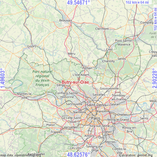
Butry-sur-Oise GPS coordinates[2]
49° 5' 18.132" North, 2° 11' 56.976" East
| Map corner | latitude | longitude |
|---|---|---|
| Upper-left | 49.54671°, | 1.49603° |
| Center: | 49.08837°, | 2.19916° |
| Lower-right: | 48.62576°, | 2.90228° |
| Map W x H: | 102.4×102.4 km | = 63.6×63.6mi |
| max Lat: | 51.07786° ⇑18.1% North |
| Butry-sur-Oise: | 49.08837° |
| min Lat: | ⇓81.9% South 41.3874° |
| min Long | Butry-sur-Oise | max Long |
| -5.08615° | 2.19916° | 9.52242° |
| W 45.5%⇐ | ⇒54.5% E |
Elevation
Elevation of Butry-sur-Oise is 26 m = 85 ft, and this is 167.7 m = 550 ft below average elevation for this country.
| Max E: |
2333 m = 7654 ft | 91.6% |
| Avg. | 193.7 m = 635 ft | |
| Butry-sur-Oise | 26 m = 85 ft | |
Min E: |
-1 m = -3 ft | 8.4% |
See also: France elevation on elevation.city.
Geographical zone
Butry-sur-Oise is located in North temperate zone (between Tropic of Cancer and the Arctic Circle). Distance of this North polar circle is 1943.1 km =1207.4 mi to North.| Distance of | km | miles | from Butry-sur-Oise |
|---|---|---|---|
| North Pole | 4548.9 | 2826.6 | to North |
| Arctic Circle | 1943.1 | 1207.4 | to North |
| Tropic Cancer | 2852.2 | 1772.3 | to South |
| Equator | 5458.1 | 3391.5 | to South |


Nearby cities:
15 places around Butry-sur-Oise: (largest is in red/bold)
• Auvers-sur-Oise
2.8 km =1.7 mi,  228°
228°
• Bessancourt
5.7 km =3.5 mi,  172°
172°
• Champagne-sur-Oise
6.6 km =4.1 mi,  28°
28°
• Frépillon
4.1 km =2.5 mi, 173°
• Hérouville
5.1 km =3.2 mi,  286°
286°
• Labbeville
6.6 km =4.1 mi,  322°
322°
• L’Isle-Adam
3 km =1.9 mi,  44°
44°
• Mours
6.9 km =4.3 mi,  46°
46°
• Mériel
1.6 km =1 mi,  148°
148°
• Méry-sur-Oise
3.3 km =2.1 mi,  190°
190°
• Nerville-la-Forêt
6 km =3.7 mi,  87°
87°
• Nesles-la-Vallée
5.3 km =3.3 mi,  337°
337°
• Parmain
2.9 km =1.8 mi,  23°
23°
• Valmondois
1.2 km =0.7 mi,  325°
325°
• Villiers-Adam
3.7 km =2.3 mi,  136°
136°
Sources, notices
• [Note1] Compared only with cities in France existing in our database
• [Src1] Map data: © OpenStreetMap contributors (CC-BY-SA)
• [Src2] Other city data from geonames.org with taken over terms of usage.
• [Src3] Geographical zone / Annual Mean Temperature by Robert A. Rohde @ Wikipedia
