Hérouville geodata
Hérouville (Île-de-France) is a populated place; located in France in Europe/Paris (GMT+2) time zone. With population of 553 people, there are 14157 cities with bigger population in this country. Compared to other cities in France, 82.2% of cities are located further ↓South; 55.4% of cities are located further →East and 54.8% of cities have higher elevation than Hérouville. Note1
Administrative division(s):
- Level 1: Île-de-France
- Level 2: Département du Val-d’Oise
- Level 3: Arrondissement de Pontoise
- Level 4: Hérouville-en-Vexin


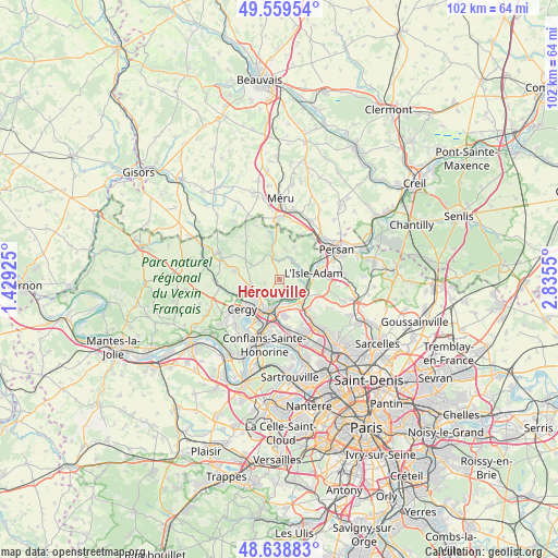
Hérouville GPS coordinates[2]
49° 6' 4.752" North, 2° 7' 56.532" East
| Map corner | latitude | longitude |
|---|---|---|
| Upper-left | 49.55954°, | 1.42925° |
| Center: | 49.10132°, | 2.13237° |
| Lower-right: | 48.63883°, | 2.8355° |
| Map W x H: | 102.4×102.4 km | = 63.6×63.6mi |
| max Lat: | 51.07786° ⇑17.8% North |
| Hérouville: | 49.10132° |
| min Lat: | ⇓82.2% South 41.3874° |
| min Long | Hérouville | max Long |
| -5.08615° | 2.13237° | 9.52242° |
| W 44.6%⇐ | ⇒55.4% E |
Elevation
Elevation of Hérouville is 117 m = 384 ft, and this is 76.7 m = 252 ft below average elevation for this country.
| Max E: |
2333 m = 7654 ft | 54.8% |
| Avg. | 193.7 m = 635 ft | |
| Hérouville | 117 m = 384 ft | |
Min E: |
-1 m = -3 ft | 45.2% |
See also: France elevation on elevation.city.
Geographical zone
Hérouville is located in North temperate zone (between Tropic of Cancer and the Arctic Circle). Distance of this North polar circle is 1941.6 km =1206.5 mi to North.| Distance of | km | miles | from Hérouville |
|---|---|---|---|
| North Pole | 4547.5 | 2825.7 | to North |
| Arctic Circle | 1941.6 | 1206.5 | to North |
| Tropic Cancer | 2853.6 | 1773.1 | to South |
| Equator | 5459.6 | 3392.4 | to South |


Nearby cities:
15 places around Hérouville: (largest is in red/bold)
• Auvers-sur-Oise
4.3 km =2.7 mi,  140°
140°
• Butry-sur-Oise
5.1 km =3.2 mi,  106°
106°
• Ennery
3.5 km =2.2 mi,  213°
213°
• Génicourt
4.9 km =3 mi,  253°
253°
• Labbeville
3.9 km =2.4 mi,  12°
12°
• Mériel
6.3 km =3.9 mi,  116°
116°
• Méry-sur-Oise
6.4 km =4 mi, 137°
• Nesles-la-Vallée
4.4 km =2.7 mi,  39°
39°
• Osny
6.1 km =3.8 mi,  235°
235°
• Parmain
6.1 km =3.8 mi,  78°
78°
• Pontoise
6.2 km =3.9 mi,  202°
202°
• Saint-Ouen-l’Aumône
6.5 km =4 mi,  187°
187°
• Vallangoujard
4.2 km =2.6 mi,  341°
341°
• Valmondois
4.2 km =2.6 mi,  96°
96°
• Épiais-Rhus
5.6 km =3.5 mi,  294°
294°
Sources, notices
• [Note1] Compared only with cities in France existing in our database
• [Src1] Map data: © OpenStreetMap contributors (CC-BY-SA)
• [Src2] Other city data from geonames.org with taken over terms of usage.
• [Src3] Geographical zone / Annual Mean Temperature by Robert A. Rohde @ Wikipedia
