Burgnac geodata
Burgnac (Nouvelle-Aquitaine) is a populated place; located in France in Europe/Paris (GMT+2) time zone. With population of 558 people, there are 14045 cities with bigger population in this country. Compared to other cities in France, 70.5% of cities are located further ↑North; 67.3% of cities are located further →East and 81.1% of cities have lower elevation than Burgnac. Note1
Administrative division(s):
- Level 1: Nouvelle-Aquitaine
- Level 2: Haute-Vienne
- Level 3: Arrondissement de Limoges
- Level 4: Burgnac


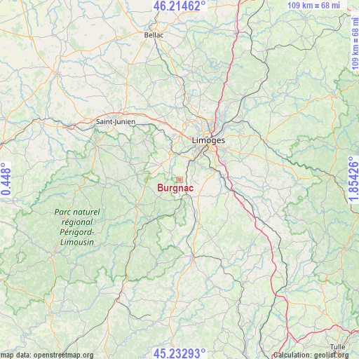
Burgnac GPS coordinates[2]
45° 43' 33.348" North, 1° 9' 4.068" East
| Map corner | latitude | longitude |
|---|---|---|
| Upper-left | 46.21462°, | 0.448° |
| Center: | 45.72593°, | 1.15113° |
| Lower-right: | 45.23293°, | 1.85426° |
| Map W x H: | 109.2×109.2 km | = 67.9×67.9mi |
| max Lat: | 51.07786° ⇑70.5% North |
| Burgnac: | 45.72593° |
| min Lat: | ⇓29.5% South 41.3874° |
| min Long | Burgnac | max Long |
| -5.08615° | 1.15113° | 9.52242° |
| W 32.7%⇐ | ⇒67.3% E |
Elevation
Elevation of Burgnac is 301 m = 988 ft, and this is 107.3 m = 352 ft above average elevation for this country.
| Max E: |
2333 m = 7654 ft | 18.9% |
| Burgnac | 301 m 988 ft | |
| Avg. | 193.7 m = 635 ft | |
Min E: |
-1 m = -3 ft | 81.1% |
See also: France elevation on elevation.city.
Geographical zone
Burgnac is located in North temperate zone (between Tropic of Cancer and the Arctic Circle). Distance of this North polar circle is 2316.9 km =1439.7 mi to North.| Distance of | km | miles | from Burgnac |
|---|---|---|---|
| North Pole | 4922.8 | 3058.9 | to North |
| Arctic Circle | 2316.9 | 1439.7 | to North |
| Tropic Cancer | 2478.3 | 1539.9 | to South |
| Equator | 5084.2 | 3159.2 | to South |


Nearby cities:
15 places around Burgnac: (largest is in red/bold)
• Aixe-sur-Vienne
8 km =5 mi,  351°
351°
• Beynac
4.7 km =2.9 mi,  15°
15°
• Bosmie-l'Aiguille
4.6 km =2.9 mi,  54°
54°
• Condat-sur-Vienne
9.8 km =6.1 mi,  39°
39°
• Flavignac
5.2 km =3.2 mi,  242°
242°
• Isle
10.5 km =6.5 mi,  33°
33°
• Jourgnac
4.9 km =3 mi,  98°
98°
• Les Cars
7.9 km =4.9 mi,  230°
230°
• Nexon
5.8 km =3.6 mi,  152°
152°
• Saint-Hilaire-les-Places
9 km =5.6 mi,  176°
176°
• Saint-Martin-le-Vieux
3.3 km =2.1 mi,  309°
309°
• Saint-Maurice-les-Brousses
7.2 km =4.5 mi,  113°
113°
• Saint-Priest-sous-Aixe
10.9 km =6.8 mi,  338°
338°
• Solignac
10.1 km =6.3 mi,  71°
71°
• Séreilhac
7.2 km =4.5 mi, 311°
Sources, notices
• [Note1] Compared only with cities in France existing in our database
• [Src1] Map data: © OpenStreetMap contributors (CC-BY-SA)
• [Src2] Other city data from geonames.org with taken over terms of usage.
• [Src3] Geographical zone / Annual Mean Temperature by Robert A. Rohde @ Wikipedia
