Aixe-sur-Vienne geodata
Aixe-sur-Vienne (Nouvelle-Aquitaine) is a populated place; located in France in Europe/Paris (GMT+2) time zone. With population of 5,661 people, there are 1754 cities with bigger population in this country. Compared to other cities in France, 69.3% of cities are located further ↑North; 67.5% of cities are located further →East and 70.6% of cities have lower elevation than Aixe-sur-Vienne. Note1
Administrative division(s):
- Level 1: Nouvelle-Aquitaine
- Level 2: Haute-Vienne
- Level 3: Arrondissement de Limoges
- Level 4: Aixe-sur-Vienne


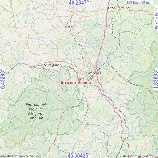
Aixe-sur-Vienne GPS coordinates[2]
45° 47' 47.868" North, 1° 8' 8.916" East
| Map corner | latitude | longitude |
|---|---|---|
| Upper-left | 46.2847°, | 0.43268° |
| Center: | 45.79663°, | 1.13581° |
| Lower-right: | 45.30425°, | 1.83893° |
| Map W x H: | 109×109 km | = 67.7×67.7mi |
| max Lat: | 51.07786° ⇑69.3% North |
| Aixe-sur-Vienne: | 45.79663° |
| min Lat: | ⇓30.7% South 41.3874° |
| min Long | Aixe-sur-Vienne | max Long |
| -5.08615° | 1.13581° | 9.52242° |
| W 32.5%⇐ | ⇒67.5% E |
Elevation
Elevation of Aixe-sur-Vienne is 222 m = 728 ft, and this is 28.3 m = 93 ft above average elevation for this country.
| Max E: |
2333 m = 7654 ft | 29.4% |
| Aixe-sur-Vienne | 222 m 728 ft | |
| Avg. | 193.7 m = 635 ft | |
Min E: |
-1 m = -3 ft | 70.6% |
See also: France elevation on elevation.city.
Geographical zone
Aixe-sur-Vienne is located in North temperate zone (between Tropic of Cancer and the Arctic Circle). Distance of this North polar circle is 2309.1 km =1434.8 mi to North.| Distance of | km | miles | from Aixe-sur-Vienne |
|---|---|---|---|
| North Pole | 4915 | 3054 | to North |
| Arctic Circle | 2309.1 | 1434.8 | to North |
| Tropic Cancer | 2486.2 | 1544.9 | to South |
| Equator | 5092.1 | 3164.1 | to South |


Nearby cities:
15 places around Aixe-sur-Vienne: (largest is in red/bold)
• Beynac
4.1 km =2.5 mi,  142°
142°
• Bosmie-l'Aiguille
7.2 km =4.5 mi, 136°
• Burgnac
8 km =5 mi,  171°
171°
• Cognac-la-Forêt
10.6 km =6.6 mi,  292°
292°
• Condat-sur-Vienne
7.5 km =4.7 mi,  92°
92°
• Flavignac
10.8 km =6.7 mi,  198°
198°
• Isle
7.1 km =4.4 mi,  82°
82°
• Jourgnac
10.5 km =6.5 mi, 144°
• Limoges
9.6 km =6 mi,  64°
64°
• Saint-Martin-le-Vieux
5.9 km =3.7 mi,  193°
193°
• Saint-Priest-sous-Aixe
3.6 km =2.2 mi,  309°
309°
• Solignac
11.7 km =7.3 mi,  113°
113°
• Séreilhac
5.2 km =3.2 mi,  234°
234°
• Verneuil-sur-Vienne
5.8 km =3.6 mi,  353°
353°
• Veyrac
11.4 km =7.1 mi, 348°
Sources, notices
• [Note1] Compared only with cities in France existing in our database
• [Src1] Map data: © OpenStreetMap contributors (CC-BY-SA)
• [Src2] Other city data from geonames.org with taken over terms of usage.
• [Src3] Geographical zone / Annual Mean Temperature by Robert A. Rohde @ Wikipedia
