Buellas geodata
Buellas (Auvergne-Rhône-Alpes) is a populated place; located in France in Europe/Paris (GMT+2) time zone. With population of 1,594 people, there are 5850 cities with bigger population in this country. Compared to other cities in France, 63.4% of cities are located further ↑North; 79.1% of cities are located further ←West and 70.6% of cities have lower elevation than Buellas. Note1
Administrative division(s):
- Level 1: Auvergne-Rhône-Alpes
- Level 2: Département de l'Ain
- Level 3: Arrondissement de Bourg-en-Bresse
- Level 4: Buellas


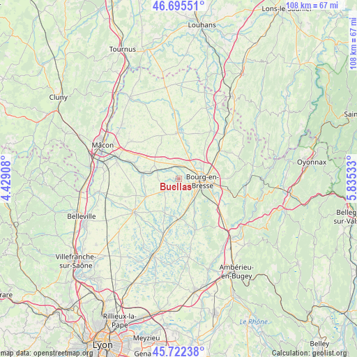
Buellas GPS coordinates[2]
46° 12' 39.96" North, 5° 7' 55.92" East
| Map corner | latitude | longitude |
|---|---|---|
| Upper-left | 46.69551°, | 4.42908° |
| Center: | 46.2111°, | 5.1322° |
| Lower-right: | 45.72238°, | 5.83533° |
| Map W x H: | 108.2×108.2 km | = 67.2×67.2mi |
| max Lat: | 51.07786° ⇑63.4% North |
| Buellas: | 46.2111° |
| min Lat: | ⇓36.6% South 41.3874° |
| min Long | Buellas | max Long |
| -5.08615° | 5.1322° | 9.52242° |
| W 79.1%⇐ | ⇒20.9% E |
Elevation
Elevation of Buellas is 222 m = 728 ft, and this is 28.3 m = 93 ft above average elevation for this country.
| Max E: |
2333 m = 7654 ft | 29.4% |
| Buellas | 222 m 728 ft | |
| Avg. | 193.7 m = 635 ft | |
Min E: |
-1 m = -3 ft | 70.6% |
See also: France elevation on elevation.city.
Geographical zone
Buellas is located in North temperate zone (between Tropic of Cancer and the Arctic Circle). Distance of this North polar circle is 2263 km =1406.2 mi to North.| Distance of | km | miles | from Buellas |
|---|---|---|---|
| North Pole | 4868.9 | 3025.4 | to North |
| Arctic Circle | 2263 | 1406.2 | to North |
| Tropic Cancer | 2532.3 | 1573.5 | to South |
| Equator | 5138.2 | 3192.7 | to South |


Nearby cities:
15 places around Buellas: (largest is in red/bold)
• Bourg-en-Bresse
7.2 km =4.5 mi,  94°
94°
• Champagne
7.7 km =4.8 mi,  62°
62°
• Chaveyriat
5.7 km =3.5 mi,  255°
255°
• Condeissiat
7.3 km =4.5 mi,  213°
213°
• Curtafond
7.7 km =4.8 mi,  333°
333°
• Montcet
1.5 km =0.9 mi,  274°
274°
• Montracol
1.9 km =1.2 mi, 208°
• Mézériat
7.2 km =4.5 mi,  293°
293°
• Polliat
4.2 km =2.6 mi,  354°
354°
• Péronnas
6.8 km =4.2 mi,  117°
117°
• Saint-André-sur-Vieux-Jonc
6 km =3.7 mi,  168°
168°
• Saint-Denis-lès-Bourg
4.5 km =2.8 mi,  102°
102°
• Saint-Martin-le-Châtel
7.7 km =4.8 mi, 350°
• Saint-Rémy
3.5 km =2.2 mi,  133°
133°
• Vandeins
4.1 km =2.5 mi,  278°
278°
Sources, notices
• [Note1] Compared only with cities in France existing in our database
• [Src1] Map data: © OpenStreetMap contributors (CC-BY-SA)
• [Src2] Other city data from geonames.org with taken over terms of usage.
• [Src3] Geographical zone / Annual Mean Temperature by Robert A. Rohde @ Wikipedia
