Brouckerque geodata
Brouckerque (Hauts-de-France) is a populated place; located in France in Europe/Paris (GMT+2) time zone. With population of 1,208 people, there are 7482 cities with bigger population in this country. Compared to other cities in France, 99.8% of cities are located further ↓South; 52.8% of cities are located further →East and 100% of cities have higher elevation than Brouckerque. Note1
Administrative division(s):
- Level 1: Hauts-de-France
- Level 2: Nord
- Level 3: Arrondissement de Dunkerque
- Level 4: Brouckerque


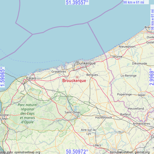
Brouckerque GPS coordinates[2]
50° 57' 17.136" North, 2° 17' 37.608" East
| Map corner | latitude | longitude |
|---|---|---|
| Upper-left | 51.39557°, | 1.59065° |
| Center: | 50.95476°, | 2.29378° |
| Lower-right: | 50.50972°, | 2.9969° |
| Map W x H: | 98.5×98.5 km | = 61.2×61.2mi |
| max Lat: | 51.07786° ⇑0.2% North |
| Brouckerque: | 50.95476° |
| min Lat: | ⇓99.8% South 41.3874° |
| min Long | Brouckerque | max Long |
| -5.08615° | 2.29378° | 9.52242° |
| W 47.2%⇐ | ⇒52.8% E |
Elevation
Elevation of Brouckerque is 1 m = 3 ft, and this is 192.7 m = 632 ft below average elevation for this country.
| Max E: |
2333 m = 7654 ft | 100% |
| Avg. | 193.7 m = 635 ft | |
| Brouckerque | 1 m = 3 ft | |
Min E: |
-1 m = -3 ft | 0% |
See also: France elevation on elevation.city.
Geographical zone
Brouckerque is located in North temperate zone (between Tropic of Cancer and the Arctic Circle). Distance of this North polar circle is 1735.5 km =1078.4 mi to North.| Distance of | km | miles | from Brouckerque |
|---|---|---|---|
| North Pole | 4341.4 | 2697.6 | to North |
| Arctic Circle | 1735.5 | 1078.4 | to North |
| Tropic Cancer | 3059.7 | 1901.2 | to South |
| Equator | 5665.6 | 3520.4 | to South |


Nearby cities:
15 places around Brouckerque: (largest is in red/bold)
• Armbouts-Cappel
4.8 km =3 mi,  59°
59°
• Bergues
9.8 km =6.1 mi,  80°
80°
• Bierne
8.2 km =5.1 mi, 84°
• Bourbourg
6.9 km =4.3 mi,  263°
263°
• Cappelle-la-Grande
6.8 km =4.2 mi,  42°
42°
• Crochte
6.9 km =4.3 mi,  108°
108°
• Fort-Mardyck
8.3 km =5.2 mi,  6°
6°
• Grande-Synthe
6.8 km =4.2 mi,  3°
3°
• Looberghe
4.4 km =2.7 mi,  197°
197°
• Loon-Plage
7.1 km =4.4 mi,  311°
311°
• Pitgam
4 km =2.5 mi,  140°
140°
• Saint-Pol-sur-Mer
9.1 km =5.7 mi,  20°
20°
• Socx
9.4 km =5.8 mi,  103°
103°
• Spycker
2.5 km =1.6 mi,  50°
50°
• Steene
5.2 km =3.2 mi,  93°
93°
Sources, notices
• [Note1] Compared only with cities in France existing in our database
• [Src1] Map data: © OpenStreetMap contributors (CC-BY-SA)
• [Src2] Other city data from geonames.org with taken over terms of usage.
• [Src3] Geographical zone / Annual Mean Temperature by Robert A. Rohde @ Wikipedia
