Socx geodata
Socx (Hauts-de-France) is a populated place; located in France in Europe/Paris (GMT+2) time zone. With population of 1,034 people, there are 8580 cities with bigger population in this country. Compared to other cities in France, 99.8% of cities are located further ↓South; 50.7% of cities are located further →East and 89.5% of cities have higher elevation than Socx. Note1
Administrative division(s):
- Level 1: Hauts-de-France
- Level 2: Nord
- Level 3: Arrondissement de Dunkerque
- Level 4: Socx


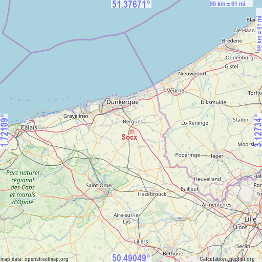
Socx GPS coordinates[2]
50° 56' 8.556" North, 2° 25' 27.192" East
| Map corner | latitude | longitude |
|---|---|---|
| Upper-left | 51.37671°, | 1.72109° |
| Center: | 50.93571°, | 2.42422° |
| Lower-right: | 50.49049°, | 3.12734° |
| Map W x H: | 98.5×98.5 km | = 61.2×61.2mi |
| max Lat: | 51.07786° ⇑0.2% North |
| Socx: | 50.93571° |
| min Lat: | ⇓99.8% South 41.3874° |
| min Long | Socx | max Long |
| -5.08615° | 2.42422° | 9.52242° |
| W 49.3%⇐ | ⇒50.7% E |
Elevation
Elevation of Socx is 31 m = 102 ft, and this is 162.7 m = 534 ft below average elevation for this country.
| Max E: |
2333 m = 7654 ft | 89.5% |
| Avg. | 193.7 m = 635 ft | |
| Socx | 31 m = 102 ft | |
Min E: |
-1 m = -3 ft | 10.5% |
See also: France elevation on elevation.city.
Geographical zone
Socx is located in North temperate zone (between Tropic of Cancer and the Arctic Circle). Distance of this North polar circle is 1737.7 km =1079.8 mi to North.| Distance of | km | miles | from Socx |
|---|---|---|---|
| North Pole | 4343.5 | 2698.9 | to North |
| Arctic Circle | 1737.7 | 1079.8 | to North |
| Tropic Cancer | 3057.6 | 1899.9 | to South |
| Equator | 5663.5 | 3519.1 | to South |


Nearby cities:
15 places around Socx: (largest is in red/bold)
• Armbouts-Cappel
6.7 km =4.2 mi,  312°
312°
• Bergues
3.7 km =2.3 mi,  8°
8°
• Bierne
3.1 km =1.9 mi,  340°
340°
• Coudekerque-Village
7.2 km =4.5 mi,  355°
355°
• Crochte
2.6 km =1.6 mi,  268°
268°
• Esquelbecq
5.5 km =3.4 mi,  174°
174°
• Hoymille
4.3 km =2.7 mi,  21°
21°
• Pitgam
6.6 km =4.1 mi,  261°
261°
• Quaëdypre
2.1 km =1.3 mi,  91°
91°
• Rexpoëde
8.1 km =5 mi, 87°
• Steene
4.3 km =2.7 mi,  295°
295°
• Warhem
6.6 km =4.1 mi,  47°
47°
• West-Cappel
5.7 km =3.5 mi,  96°
96°
• Wormhout
6.8 km =4.2 mi,  152°
152°
• Zegerscappel
6.1 km =3.8 mi,  196°
196°
Sources, notices
• [Note1] Compared only with cities in France existing in our database
• [Src1] Map data: © OpenStreetMap contributors (CC-BY-SA)
• [Src2] Other city data from geonames.org with taken over terms of usage.
• [Src3] Geographical zone / Annual Mean Temperature by Robert A. Rohde @ Wikipedia
