Bouin-Plumoison geodata
Bouin-Plumoison (Hauts-de-France) is a populated place; located in France in Europe/Paris (GMT+2) time zone. With population of 523 people, there are 14759 cities with bigger population in this country. Compared to other cities in France, 96.3% of cities are located further ↓South; 57.3% of cities are located further →East and 88.3% of cities have higher elevation than Bouin-Plumoison. Note1
Administrative division(s):
- Level 1: Hauts-de-France
- Level 2: Pas-de-Calais
- Level 3: Arrondissement de Montreuil
- Level 4: Bouin-Plumoison


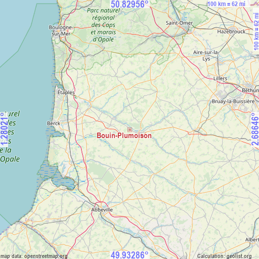
Bouin-Plumoison GPS coordinates[2]
50° 22' 59.988" North, 1° 58' 59.988" East
| Map corner | latitude | longitude |
|---|---|---|
| Upper-left | 50.82956°, | 1.28021° |
| Center: | 50.38333°, | 1.98333° |
| Lower-right: | 49.93286°, | 2.68646° |
| Map W x H: | 99.7×99.7 km | = 62×62mi |
| max Lat: | 51.07786° ⇑3.7% North |
| Bouin-Plumoison: | 50.38333° |
| min Lat: | ⇓96.3% South 41.3874° |
| min Long | Bouin-Plumoison | max Long |
| -5.08615° | 1.98333° | 9.52242° |
| W 42.7%⇐ | ⇒57.3% E |
Elevation
Elevation of Bouin-Plumoison is 34 m = 112 ft, and this is 159.7 m = 524 ft below average elevation for this country.
| Max E: |
2333 m = 7654 ft | 88.3% |
| Avg. | 193.7 m = 635 ft | |
| Bouin-Plumoison | 34 m = 112 ft | |
Min E: |
-1 m = -3 ft | 11.7% |
See also: France elevation on elevation.city.
Geographical zone
Bouin-Plumoison is located in North temperate zone (between Tropic of Cancer and the Arctic Circle). Distance of this North polar circle is 1799.1 km =1117.9 mi to North.| Distance of | km | miles | from Bouin-Plumoison |
|---|---|---|---|
| North Pole | 4405 | 2737.1 | to North |
| Arctic Circle | 1799.1 | 1117.9 | to North |
| Tropic Cancer | 2996.2 | 1861.8 | to South |
| Equator | 5602.1 | 3481 | to South |


Nearby cities:
15 places around Bouin-Plumoison: (largest is in red/bold)
• Aubin-Saint-Vaast
1.5 km =0.9 mi,  330°
330°
• Auchy-lès-Hesdin
8.6 km =5.3 mi,  76°
76°
• Beaurainville
7.5 km =4.7 mi,  307°
307°
• Brimeux
12.5 km =7.8 mi,  302°
302°
• Buire-le-Sec
10.7 km =6.6 mi,  270°
270°
• Campagne-lès-Hesdin
7.8 km =4.8 mi,  281°
281°
• Créquy
13.3 km =8.3 mi,  22°
22°
• Ecquemicourt
3.2 km =2 mi, 311°
• Fressin
8.8 km =5.5 mi,  32°
32°
• Gouy-Saint-André
6.1 km =3.8 mi,  261°
261°
• Hesdin
4 km =2.5 mi,  105°
105°
• Huby-Saint-Leu
3.8 km =2.4 mi,  92°
92°
• Le Parcq
8.1 km =5 mi, 93°
• Marconne
4.7 km =2.9 mi, 106°
• Marconnelle
2.1 km =1.3 mi, 112°
Sources, notices
• [Note1] Compared only with cities in France existing in our database
• [Src1] Map data: © OpenStreetMap contributors (CC-BY-SA)
• [Src2] Other city data from geonames.org with taken over terms of usage.
• [Src3] Geographical zone / Annual Mean Temperature by Robert A. Rohde @ Wikipedia
