Huby-Saint-Leu geodata
Huby-Saint-Leu (Hauts-de-France) is a populated place; located in France in Europe/Paris (GMT+2) time zone. With population of 992 people, there are 8887 cities with bigger population in this country. Compared to other cities in France, 96.3% of cities are located further ↓South; 56.6% of cities are located further →East and 90.3% of cities have higher elevation than Huby-Saint-Leu. Note1
Administrative division(s):
- Level 1: Hauts-de-France
- Level 2: Pas-de-Calais
- Level 3: Arrondissement de Montreuil
- Level 4: Huby-Saint-Leu


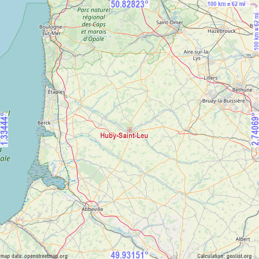
Huby-Saint-Leu GPS coordinates[2]
50° 22' 55.164" North, 2° 2' 15.252" East
| Map corner | latitude | longitude |
|---|---|---|
| Upper-left | 50.82823°, | 1.33444° |
| Center: | 50.38199°, | 2.03757° |
| Lower-right: | 49.93151°, | 2.74069° |
| Map W x H: | 99.7×99.7 km | = 62×62mi |
| max Lat: | 51.07786° ⇑3.7% North |
| Huby-Saint-Leu: | 50.38199° |
| min Lat: | ⇓96.3% South 41.3874° |
| min Long | Huby-Saint-Leu | max Long |
| -5.08615° | 2.03757° | 9.52242° |
| W 43.4%⇐ | ⇒56.6% E |
Elevation
Elevation of Huby-Saint-Leu is 29 m = 95 ft, and this is 164.7 m = 540 ft below average elevation for this country.
| Max E: |
2333 m = 7654 ft | 90.3% |
| Avg. | 193.7 m = 635 ft | |
| Huby-Saint-Leu | 29 m = 95 ft | |
Min E: |
-1 m = -3 ft | 9.7% |
See also: France elevation on elevation.city.
Geographical zone
Huby-Saint-Leu is located in North temperate zone (between Tropic of Cancer and the Arctic Circle). Distance of this North polar circle is 1799.2 km =1118 mi to North.| Distance of | km | miles | from Huby-Saint-Leu |
|---|---|---|---|
| North Pole | 4405.1 | 2737.2 | to North |
| Arctic Circle | 1799.2 | 1118 | to North |
| Tropic Cancer | 2996 | 1861.6 | to South |
| Equator | 5602 | 3480.9 | to South |


Nearby cities:
15 places around Huby-Saint-Leu: (largest is in red/bold)
• Aubin-Saint-Vaast
4.8 km =3 mi,  287°
287°
• Auchy-lès-Hesdin
5 km =3.1 mi,  64°
64°
• Beaurainville
10.9 km =6.8 mi,  295°
295°
• Blangy-sur-Ternoise
10.3 km =6.4 mi, 64°
• Bouin-Plumoison
3.8 km =2.4 mi,  272°
272°
• Campagne-lès-Hesdin
11.7 km =7.3 mi,  278°
278°
• Créquy
12.5 km =7.8 mi,  5°
5°
• Ecquemicourt
6.6 km =4.1 mi, 290°
• Fillièvres
11.2 km =7 mi,  130°
130°
• Fressin
7.6 km =4.7 mi, 6°
• Gouy-Saint-André
9.9 km =6.2 mi, 265°
• Hesdin
0.9 km =0.6 mi,  177°
177°
• Le Parcq
4.3 km =2.7 mi,  94°
94°
• Marconne
1.3 km =0.8 mi,  151°
151°
• Marconnelle
2 km =1.2 mi,  250°
250°
Sources, notices
• [Note1] Compared only with cities in France existing in our database
• [Src1] Map data: © OpenStreetMap contributors (CC-BY-SA)
• [Src2] Other city data from geonames.org with taken over terms of usage.
• [Src3] Geographical zone / Annual Mean Temperature by Robert A. Rohde @ Wikipedia
