Bondues geodata
Bondues (Hauts-de-France) is a populated place; located in France in Europe/Paris (GMT+2) time zone. With population of 11,285 people, there are 852 cities with bigger population in this country. Compared to other cities in France, 98.8% of cities are located further ↓South; 59.2% of cities are located further ←West and 84.9% of cities have higher elevation than Bondues. Note1
Administrative division(s):
- Level 1: Hauts-de-France
- Level 2: Nord
- Level 3: Arrondissement de Lille
- Level 4: Bondues


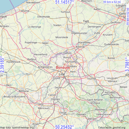
Bondues GPS coordinates[2]
50° 42' 7.056" North, 3° 5' 41.892" East
| Map corner | latitude | longitude |
|---|---|---|
| Upper-left | 51.14517°, | 2.39185° |
| Center: | 50.70196°, | 3.09497° |
| Lower-right: | 50.25452°, | 3.7981° |
| Map W x H: | 99×99 km | = 61.5×61.5mi |
| max Lat: | 51.07786° ⇑1.2% North |
| Bondues: | 50.70196° |
| min Lat: | ⇓98.8% South 41.3874° |
| min Long | Bondues | max Long |
| -5.08615° | 3.09497° | 9.52242° |
| W 59.2%⇐ | ⇒40.8% E |
Elevation
Elevation of Bondues is 42 m = 138 ft, and this is 151.7 m = 498 ft below average elevation for this country.
| Max E: |
2333 m = 7654 ft | 84.9% |
| Avg. | 193.7 m = 635 ft | |
| Bondues | 42 m = 138 ft | |
Min E: |
-1 m = -3 ft | 15.1% |
See also: France elevation on elevation.city.
Geographical zone
Bondues is located in North temperate zone (between Tropic of Cancer and the Arctic Circle). Distance of this North polar circle is 1763.6 km =1095.8 mi to North.| Distance of | km | miles | from Bondues |
|---|---|---|---|
| North Pole | 4369.5 | 2715.1 | to North |
| Arctic Circle | 1763.6 | 1095.8 | to North |
| Tropic Cancer | 3031.6 | 1883.7 | to South |
| Equator | 5637.5 | 3503 | to South |


Nearby cities:
15 places around Bondues: (largest is in red/bold)
• Croix
4.6 km =2.9 mi,  124°
124°
• La Madeleine
6.4 km =4 mi,  192°
192°
• Linselles
4.1 km =2.5 mi,  343°
343°
• Marcq-en-Barœul
4 km =2.5 mi, 191°
• Marquette-lez-Lille
3.5 km =2.2 mi,  215°
215°
• Mouvaux
2.8 km =1.7 mi,  95°
95°
• Neuville-en-Ferrain
6.8 km =4.2 mi,  40°
40°
• Quesnoy-sur-Deûle
6.8 km =4.2 mi,  280°
280°
• Roncq
6 km =3.7 mi,  17°
17°
• Roubaix
5.7 km =3.5 mi, 98°
• Saint-André-lez-Lille
5 km =3.1 mi, 218°
• Tourcoing
5.3 km =3.3 mi,  62°
62°
• Verlinghem
7.1 km =4.4 mi,  252°
252°
• Wambrechies
3.9 km =2.4 mi,  237°
237°
• Wasquehal
4.4 km =2.7 mi,  142°
142°
Sources, notices
• [Note1] Compared only with cities in France existing in our database
• [Src1] Map data: © OpenStreetMap contributors (CC-BY-SA)
• [Src2] Other city data from geonames.org with taken over terms of usage.
• [Src3] Geographical zone / Annual Mean Temperature by Robert A. Rohde @ Wikipedia
