Croix geodata
Croix (Hauts-de-France) is a populated place; located in France in Europe/Paris (GMT+2) time zone. With population of 21,361 people, there are 425 cities with bigger population in this country. Compared to other cities in France, 98.7% of cities are located further ↓South; 59.9% of cities are located further ←West and 88.3% of cities have higher elevation than Croix. Note1
Administrative division(s):
- Level 1: Hauts-de-France
- Level 2: Nord
- Level 3: Arrondissement de Lille
- Level 4: Croix


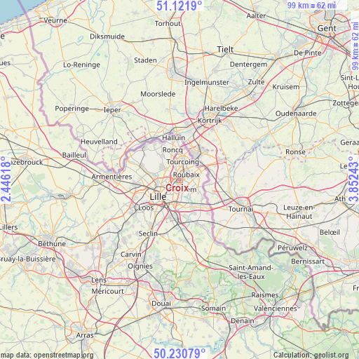
Croix GPS coordinates[2]
50° 40' 42.456" North, 3° 8' 57.48" East
| Map corner | latitude | longitude |
|---|---|---|
| Upper-left | 51.1219°, | 2.44618° |
| Center: | 50.67846°, | 3.1493° |
| Lower-right: | 50.23079°, | 3.85243° |
| Map W x H: | 99.1×99.1 km | = 61.6×61.6mi |
| max Lat: | 51.07786° ⇑1.3% North |
| Croix: | 50.67846° |
| min Lat: | ⇓98.7% South 41.3874° |
| min Long | Croix | max Long |
| -5.08615° | 3.1493° | 9.52242° |
| W 59.9%⇐ | ⇒40.1% E |
Elevation
Elevation of Croix is 34 m = 112 ft, and this is 159.7 m = 524 ft below average elevation for this country.
| Max E: |
2333 m = 7654 ft | 88.3% |
| Avg. | 193.7 m = 635 ft | |
| Croix | 34 m = 112 ft | |
Min E: |
-1 m = -3 ft | 11.7% |
See also: France elevation on elevation.city.
Geographical zone
Croix is located in North temperate zone (between Tropic of Cancer and the Arctic Circle). Distance of this North polar circle is 1766.3 km =1097.5 mi to North.| Distance of | km | miles | from Croix |
|---|---|---|---|
| North Pole | 4372.1 | 2716.7 | to North |
| Arctic Circle | 1766.3 | 1097.5 | to North |
| Tropic Cancer | 3029 | 1882.1 | to South |
| Equator | 5634.9 | 3501.4 | to South |


Nearby cities:
15 places around Croix: (largest is in red/bold)
• Bondues
4.6 km =2.9 mi,  304°
304°
• Forest-sur-Marque
5.8 km =3.6 mi,  150°
150°
• Hem
3.9 km =2.4 mi,  137°
137°
• Lannoy
4.5 km =2.8 mi,  106°
106°
• Lys-lez-Lannoy
4.9 km =3 mi, 105°
• Marcq-en-Barœul
4.8 km =3 mi,  254°
254°
• Marquette-lez-Lille
5.9 km =3.7 mi,  267°
267°
• Mons-en-Barœul
5.5 km =3.4 mi,  204°
204°
• Mouvaux
2.6 km =1.6 mi,  335°
335°
• Roubaix
2.5 km =1.6 mi,  45°
45°
• Sailly-lez-Lannoy
5.7 km =3.5 mi,  123°
123°
• Toufflers
6.3 km =3.9 mi, 108°
• Tourcoing
5.1 km =3.2 mi,  9°
9°
• Wasquehal
1.4 km =0.9 mi,  230°
230°
• Wattrelos
5.5 km =3.4 mi,  62°
62°
Sources, notices
• [Note1] Compared only with cities in France existing in our database
• [Src1] Map data: © OpenStreetMap contributors (CC-BY-SA)
• [Src2] Other city data from geonames.org with taken over terms of usage.
• [Src3] Geographical zone / Annual Mean Temperature by Robert A. Rohde @ Wikipedia
