Neuville-en-Ferrain geodata
Neuville-en-Ferrain (Hauts-de-France) is a populated place; located in France in Europe/Paris (GMT+2) time zone. With population of 9,428 people, there are 1018 cities with bigger population in this country. Compared to other cities in France, 99.1% of cities are located further ↓South; 60% of cities are located further ←West and 85.3% of cities have higher elevation than Neuville-en-Ferrain. Note1
Administrative division(s):
- Level 1: Hauts-de-France
- Level 2: Nord
- Level 3: Arrondissement de Lille
- Level 4: Neuville-en-Ferrain


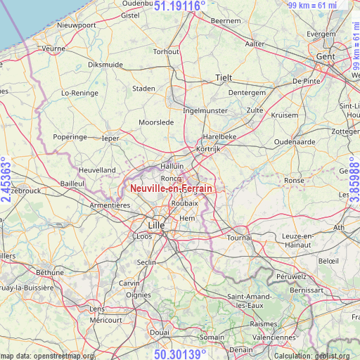
Neuville-en-Ferrain GPS coordinates[2]
50° 44' 54.204" North, 3° 9' 24.336" East
| Map corner | latitude | longitude |
|---|---|---|
| Upper-left | 51.19116°, | 2.45363° |
| Center: | 50.74839°, | 3.15676° |
| Lower-right: | 50.30139°, | 3.85988° |
| Map W x H: | 98.9×98.9 km | = 61.5×61.5mi |
| max Lat: | 51.07786° ⇑0.9% North |
| Neuville-en-Ferrain: | 50.74839° |
| min Lat: | ⇓99.1% South 41.3874° |
| min Long | Neuville-en-Fer | max Long |
| -5.08615° | 3.15676° | 9.52242° |
| W 60%⇐ | ⇒40% E |
Elevation
Elevation of Neuville-en-Ferrain is 41 m = 135 ft, and this is 152.7 m = 501 ft below average elevation for this country.
| Max E: |
2333 m = 7654 ft | 85.3% |
| Avg. | 193.7 m = 635 ft | |
| Neuville-en-Ferrain | 41 m = 135 ft | |
Min E: |
-1 m = -3 ft | 14.7% |
See also: France elevation on elevation.city.
Geographical zone
Neuville-en-Ferrain is located in North temperate zone (between Tropic of Cancer and the Arctic Circle). Distance of this North polar circle is 1758.5 km =1092.7 mi to North.| Distance of | km | miles | from Neuville-en-Ferrain |
|---|---|---|---|
| North Pole | 4364.4 | 2711.9 | to North |
| Arctic Circle | 1758.5 | 1092.7 | to North |
| Tropic Cancer | 3036.8 | 1887 | to South |
| Equator | 5642.7 | 3506.2 | to South |


Nearby cities:
15 places around Neuville-en-Ferrain: (largest is in red/bold)
• Bondues
6.8 km =4.2 mi,  220°
220°
• Bousbecque
5.7 km =3.5 mi,  296°
296°
• Croix
7.8 km =4.8 mi,  183°
183°
• Halluin
4.7 km =2.9 mi,  332°
332°
• Lannoy
9.8 km =6.1 mi,  157°
157°
• Leers
9.6 km =6 mi,  140°
140°
• Linselles
5.6 km =3.5 mi,  257°
257°
• Lys-lez-Lannoy
10 km =6.2 mi, 155°
• Mouvaux
5.7 km =3.5 mi,  196°
196°
• Roncq
2.6 km =1.6 mi,  282°
282°
• Roubaix
6.2 km =3.9 mi,  168°
168°
• Tourcoing
2.7 km =1.7 mi, 173°
• Wasquehal
8.8 km =5.5 mi,  190°
190°
• Wattrelos
6.8 km =4.2 mi, 140°
• Wervicq-Sud
8.6 km =5.3 mi,  289°
289°
Sources, notices
• [Note1] Compared only with cities in France existing in our database
• [Src1] Map data: © OpenStreetMap contributors (CC-BY-SA)
• [Src2] Other city data from geonames.org with taken over terms of usage.
• [Src3] Geographical zone / Annual Mean Temperature by Robert A. Rohde @ Wikipedia
