Bisseuil geodata
Bisseuil (Grand Est) is a populated place; located in France in Europe/Paris (GMT+2) time zone. With population of 645 people, there are 12593 cities with bigger population in this country. Compared to other cities in France, 80.8% of cities are located further ↓South; 68.7% of cities are located further ←West and 71% of cities have higher elevation than Bisseuil. Note1
Administrative division(s):
- Level 1: Grand Est
- Level 2: Marne
- Level 3: Arrondissement d'Épernay
- Level 4: Aÿ-Champagne


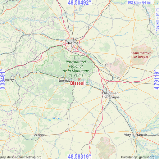
Bisseuil GPS coordinates[2]
49° 2' 46.284" North, 4° 5' 16.908" East
| Map corner | latitude | longitude |
|---|---|---|
| Upper-left | 49.50492°, | 3.38491° |
| Center: | 49.04619°, | 4.08803° |
| Lower-right: | 48.58319°, | 4.79116° |
| Map W x H: | 102.5×102.5 km | = 63.7×63.7mi |
| max Lat: | 51.07786° ⇑19.2% North |
| Bisseuil: | 49.04619° |
| min Lat: | ⇓80.8% South 41.3874° |
| min Long | Bisseuil | max Long |
| -5.08615° | 4.08803° | 9.52242° |
| W 68.7%⇐ | ⇒31.3% E |
Elevation
Elevation of Bisseuil is 76 m = 249 ft, and this is 117.7 m = 386 ft below average elevation for this country.
| Max E: |
2333 m = 7654 ft | 71% |
| Avg. | 193.7 m = 635 ft | |
| Bisseuil | 76 m = 249 ft | |
Min E: |
-1 m = -3 ft | 29% |
See also: France elevation on elevation.city.
Geographical zone
Bisseuil is located in North temperate zone (between Tropic of Cancer and the Arctic Circle). Distance of this North polar circle is 1947.7 km =1210.2 mi to North.| Distance of | km | miles | from Bisseuil |
|---|---|---|---|
| North Pole | 4553.6 | 2829.5 | to North |
| Arctic Circle | 1947.7 | 1210.2 | to North |
| Tropic Cancer | 2847.5 | 1769.4 | to South |
| Equator | 5453.4 | 3388.6 | to South |


Nearby cities:
15 places around Bisseuil: (largest is in red/bold)
• Ambonnay
7.1 km =4.4 mi,  60°
60°
• Athis
4.4 km =2.7 mi,  138°
138°
• Avenay-Val-d’Or
3.9 km =2.4 mi,  312°
312°
• Ay
6.2 km =3.9 mi,  278°
278°
• Bouzy
5.7 km =3.5 mi,  49°
49°
• Champillon
9 km =5.6 mi,  298°
298°
• Chouilly
5.9 km =3.7 mi,  246°
246°
• Condé-sur-Marne
6.7 km =4.2 mi,  91°
91°
• Germaine
8.7 km =5.4 mi,  331°
331°
• Jâlons
8.2 km =5.1 mi,  118°
118°
• Magenta
8.7 km =5.4 mi,  272°
272°
• Mareuil-sur-Ay
3.8 km =2.4 mi, 269°
• Oiry
3.6 km =2.2 mi,  226°
226°
• Plivot
3.4 km =2.1 mi,  201°
201°
• Tours-sur-Marne
2.4 km =1.5 mi,  83°
83°
Sources, notices
• [Note1] Compared only with cities in France existing in our database
• [Src1] Map data: © OpenStreetMap contributors (CC-BY-SA)
• [Src2] Other city data from geonames.org with taken over terms of usage.
• [Src3] Geographical zone / Annual Mean Temperature by Robert A. Rohde @ Wikipedia
