Chouilly geodata
Chouilly (Grand Est) is a populated place; located in France in Europe/Paris (GMT+2) time zone. With population of 897 people, there are 9685 cities with bigger population in this country. Compared to other cities in France, 80.3% of cities are located further ↓South; 68% of cities are located further ←West and 68.7% of cities have higher elevation than Chouilly. Note1
Administrative division(s):
- Level 1: Grand Est
- Level 2: Marne
- Level 3: Arrondissement d'Épernay
- Level 4: Chouilly


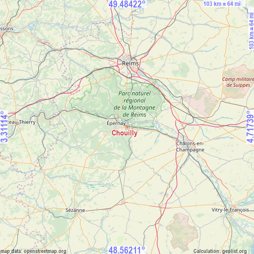
Chouilly GPS coordinates[2]
49° 1' 31.08" North, 4° 0' 51.336" East
| Map corner | latitude | longitude |
|---|---|---|
| Upper-left | 49.48422°, | 3.31114° |
| Center: | 49.0253°, | 4.01426° |
| Lower-right: | 48.56211°, | 4.71739° |
| Map W x H: | 102.5×102.5 km | = 63.7×63.7mi |
| max Lat: | 51.07786° ⇑19.7% North |
| Chouilly: | 49.0253° |
| min Lat: | ⇓80.3% South 41.3874° |
| min Long | Chouilly | max Long |
| -5.08615° | 4.01426° | 9.52242° |
| W 68%⇐ | ⇒32% E |
Elevation
Elevation of Chouilly is 81 m = 266 ft, and this is 112.7 m = 370 ft below average elevation for this country.
| Max E: |
2333 m = 7654 ft | 68.7% |
| Avg. | 193.7 m = 635 ft | |
| Chouilly | 81 m = 266 ft | |
Min E: |
-1 m = -3 ft | 31.3% |
See also: France elevation on elevation.city.
Geographical zone
Chouilly is located in North temperate zone (between Tropic of Cancer and the Arctic Circle). Distance of this North polar circle is 1950.1 km =1211.7 mi to North.| Distance of | km | miles | from Chouilly |
|---|---|---|---|
| North Pole | 4556 | 2831 | to North |
| Arctic Circle | 1950.1 | 1211.7 | to North |
| Tropic Cancer | 2845.2 | 1767.9 | to South |
| Equator | 5451.1 | 3387.2 | to South |


Nearby cities:
15 places around Chouilly: (largest is in red/bold)
• Avenay-Val-d’Or
5.5 km =3.4 mi,  26°
26°
• Avize
5.8 km =3.6 mi,  179°
179°
• Ay
3.3 km =2.1 mi,  346°
346°
• Bisseuil
5.9 km =3.7 mi,  66°
66°
• Cramant
4.5 km =2.8 mi,  201°
201°
• Dizy
5.8 km =3.6 mi,  322°
322°
• Grauves
6.8 km =4.2 mi,  212°
212°
• Magenta
4.2 km =2.6 mi,  308°
308°
• Mardeuil
6.9 km =4.3 mi,  297°
297°
• Mareuil-sur-Ay
2.8 km =1.7 mi, 34°
• Moussy
6.9 km =4.3 mi,  261°
261°
• Oiry
2.7 km =1.7 mi,  93°
93°
• Pierry
5.4 km =3.4 mi, 264°
• Plivot
4.2 km =2.6 mi,  101°
101°
• Épernay
4.3 km =2.7 mi,  292°
292°
Sources, notices
• [Note1] Compared only with cities in France existing in our database
• [Src1] Map data: © OpenStreetMap contributors (CC-BY-SA)
• [Src2] Other city data from geonames.org with taken over terms of usage.
• [Src3] Geographical zone / Annual Mean Temperature by Robert A. Rohde @ Wikipedia
