Besneville geodata
Besneville (Normandy) is a populated place; located in France in Europe/Paris (GMT+2) time zone. With population of 529 people, there are 14624 cities with bigger population in this country. Compared to other cities in France, 87.3% of cities are located further ↓South; 93.1% of cities are located further →East and 89.1% of cities have higher elevation than Besneville. Note1
Administrative division(s):
- Level 1: Normandy
- Level 2: Manche
- Level 3: Arrondissement de Cherbourg
- Level 4: Besneville


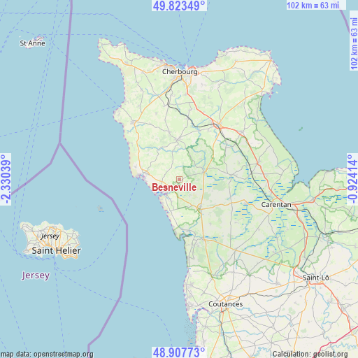
Besneville GPS coordinates[2]
49° 22' 3.864" North, 1° 37' 38.136" West
| Map corner | latitude | longitude |
|---|---|---|
| Upper-left | 49.82349°, | -2.33039° |
| Center: | 49.36774°, | -1.62726° |
| Lower-right: | 48.90773°, | -0.92414° |
| Map W x H: | 101.8×101.8 km | = 63.3×63.3mi |
| max Lat: | 51.07786° ⇑12.7% North |
| Besneville: | 49.36774° |
| min Lat: | ⇓87.3% South 41.3874° |
| min Long | Besneville | max Long |
| -5.08615° | -1.62726° | 9.52242° |
| W 6.9%⇐ | ⇒93.1% E |
Elevation
Elevation of Besneville is 32 m = 105 ft, and this is 161.7 m = 531 ft below average elevation for this country.
| Max E: |
2333 m = 7654 ft | 89.1% |
| Avg. | 193.7 m = 635 ft | |
| Besneville | 32 m = 105 ft | |
Min E: |
-1 m = -3 ft | 10.9% |
See also: France elevation on elevation.city.
Geographical zone
Besneville is located in North temperate zone (between Tropic of Cancer and the Arctic Circle). Distance of this North polar circle is 1912 km =1188.1 mi to North.| Distance of | km | miles | from Besneville |
|---|---|---|---|
| North Pole | 4517.9 | 2807.3 | to North |
| Arctic Circle | 1912 | 1188.1 | to North |
| Tropic Cancer | 2883.3 | 1791.6 | to South |
| Equator | 5489.2 | 3410.8 | to South |


Nearby cities:
15 places around Besneville: (largest is in red/bold)
• Barneville-Carteret
9.1 km =5.7 mi,  281°
281°
• Barneville-Plage
10 km =6.2 mi,  270°
270°
• Bricquebec
11.4 km =7.1 mi,  358°
358°
• La Haye-du-Puits
10.6 km =6.6 mi,  144°
144°
• Le Vrétot
11.1 km =6.9 mi,  327°
327°
• Lithaire
12.9 km =8 mi,  125°
125°
• Négreville
15.1 km =9.4 mi,  22°
22°
• Pierreville
16.2 km =10.1 mi,  316°
316°
• Portbail
6.1 km =3.8 mi,  234°
234°
• Quettetot
13.6 km =8.5 mi,  347°
347°
• Rocheville
15.4 km =9.6 mi,  8°
8°
• Saint-Germain-sur-Ay
14.9 km =9.3 mi,  170°
170°
• Saint-Sauveur-le-Vicomte
7.1 km =4.4 mi,  73°
73°
• Saint-Symphorien-le-Valois
9.7 km =6 mi,  147°
147°
• Vesly
15.6 km =9.7 mi, 145°
Sources, notices
• [Note1] Compared only with cities in France existing in our database
• [Src1] Map data: © OpenStreetMap contributors (CC-BY-SA)
• [Src2] Other city data from geonames.org with taken over terms of usage.
• [Src3] Geographical zone / Annual Mean Temperature by Robert A. Rohde @ Wikipedia
