Lithaire geodata
Lithaire (Normandy) is a populated place; located in France in Europe/Paris (GMT+2) time zone. With population of 532 people, there are 14567 cities with bigger population in this country. Compared to other cities in France, 86.1% of cities are located further ↓South; 92.1% of cities are located further →East and 85.9% of cities have higher elevation than Lithaire. Note1
Administrative division(s):
- Level 1: Normandy
- Level 2: Manche
- Level 3: Arrondissement de Coutances
- Level 4: Montsenelle


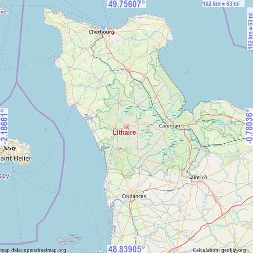
Lithaire GPS coordinates[2]
49° 17' 58.884" North, 1° 29' 0.564" West
| Map corner | latitude | longitude |
|---|---|---|
| Upper-left | 49.75607°, | -2.18661° |
| Center: | 49.29969°, | -1.48349° |
| Lower-right: | 48.83905°, | -0.78036° |
| Map W x H: | 102×102 km | = 63.4×63.4mi |
| max Lat: | 51.07786° ⇑13.9% North |
| Lithaire: | 49.29969° |
| min Lat: | ⇓86.1% South 41.3874° |
| min Long | Lithaire | max Long |
| -5.08615° | -1.48349° | 9.52242° |
| W 7.9%⇐ | ⇒92.1% E |
Elevation
Elevation of Lithaire is 40 m = 131 ft, and this is 153.7 m = 504 ft below average elevation for this country.
| Max E: |
2333 m = 7654 ft | 85.9% |
| Avg. | 193.7 m = 635 ft | |
| Lithaire | 40 m = 131 ft | |
Min E: |
-1 m = -3 ft | 14.1% |
See also: France elevation on elevation.city.
Geographical zone
Lithaire is located in North temperate zone (between Tropic of Cancer and the Arctic Circle). Distance of this North polar circle is 1919.6 km =1192.8 mi to North.| Distance of | km | miles | from Lithaire |
|---|---|---|---|
| North Pole | 4525.5 | 2812 | to North |
| Arctic Circle | 1919.6 | 1192.8 | to North |
| Tropic Cancer | 2875.7 | 1786.9 | to South |
| Equator | 5481.6 | 3406.1 | to South |


Nearby cities:
15 places around Lithaire: (largest is in red/bold)
• Auvers
11.8 km =7.3 mi,  90°
90°
• Besneville
12.9 km =8 mi,  305°
305°
• Chef-du-Pont
13.9 km =8.6 mi,  46°
46°
• Créances
12.8 km =8 mi,  209°
209°
• La Haye-du-Puits
4.5 km =2.8 mi,  255°
255°
• Lessay
9.8 km =6.1 mi,  200°
200°
• Millières
12.6 km =7.8 mi,  172°
172°
• Méautis
13.6 km =8.5 mi,  100°
100°
• Picauville
10.6 km =6.6 mi,  34°
34°
• Périers
13.7 km =8.5 mi,  156°
156°
• Saint-Germain-sur-Ay
10.8 km =6.7 mi,  228°
228°
• Saint-Sauveur-le-Vicomte
10.2 km =6.3 mi,  339°
339°
• Saint-Symphorien-le-Valois
5.2 km =3.2 mi, 263°
• Sainteny
14.1 km =8.8 mi,  119°
119°
• Vesly
5.5 km =3.4 mi, 196°
Sources, notices
• [Note1] Compared only with cities in France existing in our database
• [Src1] Map data: © OpenStreetMap contributors (CC-BY-SA)
• [Src2] Other city data from geonames.org with taken over terms of usage.
• [Src3] Geographical zone / Annual Mean Temperature by Robert A. Rohde @ Wikipedia
