Bellevaux geodata
Bellevaux (Auvergne-Rhône-Alpes) is a populated place; located in France in Europe/Paris (GMT+2) time zone. With population of 1,273 people, there are 7156 cities with bigger population in this country. Compared to other cities in France, 62.8% of cities are located further ↑North; 91.9% of cities are located further ←West and 99.2% of cities have lower elevation than Bellevaux. Note1
Administrative division(s):
- Level 1: Auvergne-Rhône-Alpes
- Level 2: Haute-Savoie
- Level 3: Arrondissement de Thonon-les-Bains
- Level 4: Bellevaux


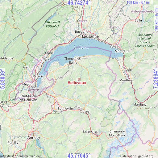
Bellevaux GPS coordinates[2]
46° 15' 31.5" North, 6° 32' 0.636" East
| Map corner | latitude | longitude |
|---|---|---|
| Upper-left | 46.74274°, | 5.83039° |
| Center: | 46.25875°, | 6.53351° |
| Lower-right: | 45.77045°, | 7.23664° |
| Map W x H: | 108.1×108.1 km | = 67.2×67.2mi |
| max Lat: | 51.07786° ⇑62.8% North |
| Bellevaux: | 46.25875° |
| min Lat: | ⇓37.2% South 41.3874° |
| min Long | Bellevaux | max Long |
| -5.08615° | 6.53351° | 9.52242° |
| W 91.9%⇐ | ⇒8.1% E |
Elevation
Elevation of Bellevaux is 1017 m = 3337 ft, and this is 823.3 m = 2701 ft above average elevation for this country.
| Max E: |
2333 m = 7654 ft | 0.8% |
| Bellevaux | 1017 m 3337 ft | |
| Avg. | 193.7 m = 635 ft | |
Min E: |
-1 m = -3 ft | 99.2% |
See also: France elevation on elevation.city.
Geographical zone
Bellevaux is located in North temperate zone (between Tropic of Cancer and the Arctic Circle). Distance of this North polar circle is 2257.7 km =1402.9 mi to North.| Distance of | km | miles | from Bellevaux |
|---|---|---|---|
| North Pole | 4863.6 | 3022.1 | to North |
| Arctic Circle | 2257.7 | 1402.9 | to North |
| Tropic Cancer | 2537.6 | 1576.8 | to South |
| Equator | 5143.5 | 3196 | to South |


Nearby cities:
15 places around Bellevaux: (largest is in red/bold)
• Allinges
10.1 km =6.3 mi,  327°
327°
• Armoy
10.3 km =6.4 mi,  352°
352°
• Burdignin
9.4 km =5.8 mi,  243°
243°
• Cervens
7.8 km =4.8 mi,  292°
292°
• Draillant
7.7 km =4.8 mi,  311°
311°
• Fessy
9.4 km =5.8 mi,  280°
280°
• Habère-Lullin
6.6 km =4.1 mi,  245°
245°
• Habère-Poche
4.8 km =3 mi,  258°
258°
• Lullin
3 km =1.9 mi,  344°
344°
• Lully
9.4 km =5.8 mi, 287°
• Lyaud
9 km =5.6 mi,  356°
356°
• Orcier
7 km =4.3 mi, 330°
• Perrignier
8.9 km =5.5 mi, 305°
• Saint-Jean-d’Aulps
9.6 km =6 mi,  106°
106°
• Vailly
4.8 km =3 mi,  5°
5°
Sources, notices
• [Note1] Compared only with cities in France existing in our database
• [Src1] Map data: © OpenStreetMap contributors (CC-BY-SA)
• [Src2] Other city data from geonames.org with taken over terms of usage.
• [Src3] Geographical zone / Annual Mean Temperature by Robert A. Rohde @ Wikipedia
