Beaufort geodata
Beaufort (Auvergne-Rhône-Alpes) is a populated place; located in France in Europe/Paris (GMT+2) time zone. With population of 2,170 people, there are 4421 cities with bigger population in this country. Compared to other cities in France, 70.6% of cities are located further ↑North; 92.2% of cities are located further ←West and 98.3% of cities have lower elevation than Beaufort. Note1
Administrative division(s):
- Level 1: Auvergne-Rhône-Alpes
- Level 2: Savoie
- Level 3: Albertville
- Level 4: Beaufort


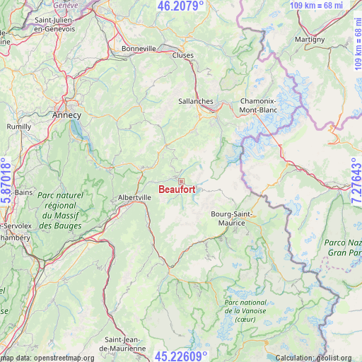
Beaufort GPS coordinates[2]
45° 43' 8.94" North, 6° 34' 23.916" East
| Map corner | latitude | longitude |
|---|---|---|
| Upper-left | 46.2079°, | 5.87018° |
| Center: | 45.71915°, | 6.57331° |
| Lower-right: | 45.22609°, | 7.27643° |
| Map W x H: | 109.2×109.2 km | = 67.9×67.9mi |
| max Lat: | 51.07786° ⇑70.6% North |
| Beaufort: | 45.71915° |
| min Lat: | ⇓29.4% South 41.3874° |
| min Long | Beaufort | max Long |
| -5.08615° | 6.57331° | 9.52242° |
| W 92.2%⇐ | ⇒7.8% E |
Elevation
Elevation of Beaufort is 863 m = 2831 ft, and this is 669.3 m = 2196 ft above average elevation for this country.
| Max E: |
2333 m = 7654 ft | 1.7% |
| Beaufort | 863 m 2831 ft | |
| Avg. | 193.7 m = 635 ft | |
Min E: |
-1 m = -3 ft | 98.3% |
See also: France elevation on elevation.city.
Geographical zone
Beaufort is located in North temperate zone (between Tropic of Cancer and the Arctic Circle). Distance of this North polar circle is 2317.7 km =1440.2 mi to North.| Distance of | km | miles | from Beaufort |
|---|---|---|---|
| North Pole | 4923.6 | 3059.4 | to North |
| Arctic Circle | 2317.7 | 1440.2 | to North |
| Tropic Cancer | 2477.6 | 1539.5 | to South |
| Equator | 5083.5 | 3158.7 | to South |


Nearby cities:
15 places around Beaufort: (largest is in red/bold)
• Albertville
15 km =9.3 mi,  250°
250°
• Esserts-Blay
15.8 km =9.8 mi,  222°
222°
• Flumet
11.9 km =7.4 mi,  337°
337°
• Hauteluce
3.4 km =2.1 mi,  10°
10°
• La Bâthie
14 km =8.7 mi, 223°
• Marthod
13.3 km =8.3 mi,  273°
273°
• Megève
15.7 km =9.8 mi, 12°
• Notre-Dame-de-Bellecombe
10.8 km =6.7 mi, 336°
• Pallud
14.8 km =9.2 mi, 254°
• Praz-sur-Arly
13.1 km =8.1 mi,  359°
359°
• Queige
8.8 km =5.5 mi, 270°
• Tours-en-Savoie
12.6 km =7.8 mi,  234°
234°
• Ugine
12.9 km =8 mi,  288°
288°
• Venthon
13.2 km =8.2 mi, 254°
• Villard-sur-Doron
2.7 km =1.7 mi, 286°
Sources, notices
• [Note1] Compared only with cities in France existing in our database
• [Src1] Map data: © OpenStreetMap contributors (CC-BY-SA)
• [Src2] Other city data from geonames.org with taken over terms of usage.
• [Src3] Geographical zone / Annual Mean Temperature by Robert A. Rohde @ Wikipedia
