Baye geodata
Baye (Brittany) is a populated place; located in France in Europe/Paris (GMT+2) time zone. With population of 977 people, there are 9003 cities with bigger population in this country. Compared to other cities in France, 56.7% of cities are located further ↓South; 98.5% of cities are located further →East and 75.4% of cities have higher elevation than Baye. Note1
Administrative division(s):
- Level 1: Brittany
- Level 2: Département du Finistère
- Level 3: Arrondissement de Quimper
- Level 4: Baye


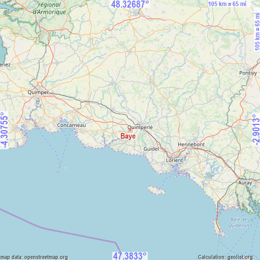
Baye GPS coordinates[2]
47° 51' 26.028" North, 3° 36' 15.912" West
| Map corner | latitude | longitude |
|---|---|---|
| Upper-left | 48.32687°, | -4.30755° |
| Center: | 47.85723°, | -3.60442° |
| Lower-right: | 47.3833°, | -2.9013° |
| Map W x H: | 104.9×104.9 km | = 65.2×65.2mi |
| max Lat: | 51.07786° ⇑43.3% North |
| Baye: | 47.85723° |
| min Lat: | ⇓56.7% South 41.3874° |
| min Long | Baye | max Long |
| -5.08615° | -3.60442° | 9.52242° |
| W 1.5%⇐ | ⇒98.5% E |
Elevation
Elevation of Baye is 66 m = 217 ft, and this is 127.7 m = 419 ft below average elevation for this country.
| Max E: |
2333 m = 7654 ft | 75.4% |
| Avg. | 193.7 m = 635 ft | |
| Baye | 66 m = 217 ft | |
Min E: |
-1 m = -3 ft | 24.6% |
See also: France elevation on elevation.city.
Geographical zone
Baye is located in North temperate zone (between Tropic of Cancer and the Arctic Circle). Distance of this North polar circle is 2079.9 km =1292.4 mi to North.| Distance of | km | miles | from Baye |
|---|---|---|---|
| North Pole | 4685.8 | 2911.6 | to North |
| Arctic Circle | 2079.9 | 1292.4 | to North |
| Tropic Cancer | 2715.3 | 1687.2 | to South |
| Equator | 5321.2 | 3306.4 | to South |


Nearby cities:
15 places around Baye: (largest is in red/bold)
• Arzano
13.2 km =8.2 mi,  68°
68°
• Bannalec
10.9 km =6.8 mi,  320°
320°
• Clohars-Carnoët
7 km =4.3 mi,  167°
167°
• Guidel-Plage
11.7 km =7.3 mi,  148°
148°
• Lanmeur
8.8 km =5.5 mi,  252°
252°
• Le Trévoux
5 km =3.1 mi,  326°
326°
• Locunolé
12.9 km =8 mi,  46°
46°
• Mellac
5.5 km =3.4 mi,  21°
21°
• Moëlan-sur-Mer
5.1 km =3.2 mi,  200°
200°
• Pont-Aven
10.9 km =6.8 mi,  265°
265°
• Quimperlé
4.2 km =2.6 mi,  75°
75°
• Riec-sur-Belon
7.6 km =4.7 mi, 249°
• Rédené
10.3 km =6.4 mi,  94°
94°
• Saint-Thurien
10.5 km =6.5 mi,  348°
348°
• Tréméven
7.1 km =4.4 mi, 48°
Sources, notices
• [Note1] Compared only with cities in France existing in our database
• [Src1] Map data: © OpenStreetMap contributors (CC-BY-SA)
• [Src2] Other city data from geonames.org with taken over terms of usage.
• [Src3] Geographical zone / Annual Mean Temperature by Robert A. Rohde @ Wikipedia
