Rédené geodata
Rédené (Brittany) is a populated place; located in France in Europe/Paris (GMT+2) time zone. With population of 2,456 people, there are 3950 cities with bigger population in this country. Compared to other cities in France, 56.6% of cities are located further ↓South; 98.3% of cities are located further →East and 83.8% of cities have higher elevation than Rédené. Note1
Administrative division(s):
- Level 1: Brittany
- Level 2: Département du Finistère
- Level 3: Arrondissement de Quimper
- Level 4: Rédené


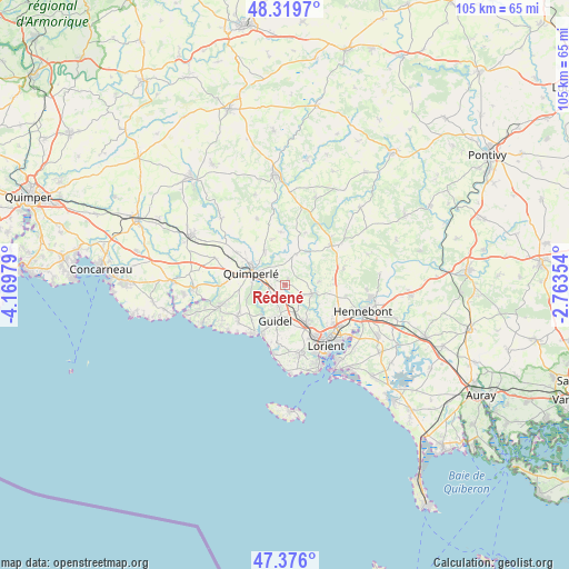
Rédené GPS coordinates[2]
47° 51' 0" North, 3° 28' 0.012" West
| Map corner | latitude | longitude |
|---|---|---|
| Upper-left | 48.3197°, | -4.16979° |
| Center: | 47.85°, | -3.46667° |
| Lower-right: | 47.376°, | -2.76354° |
| Map W x H: | 104.9×104.9 km | = 65.2×65.2mi |
| max Lat: | 51.07786° ⇑43.4% North |
| Rédené: | 47.85° |
| min Lat: | ⇓56.6% South 41.3874° |
| min Long | Rédené | max Long |
| -5.08615° | -3.46667° | 9.52242° |
| W 1.7%⇐ | ⇒98.3% E |
Elevation
Elevation of Rédené is 45 m = 148 ft, and this is 148.7 m = 488 ft below average elevation for this country.
| Max E: |
2333 m = 7654 ft | 83.8% |
| Avg. | 193.7 m = 635 ft | |
| Rédené | 45 m = 148 ft | |
Min E: |
-1 m = -3 ft | 16.2% |
See also: France elevation on elevation.city.
Geographical zone
Rédené is located in North temperate zone (between Tropic of Cancer and the Arctic Circle). Distance of this North polar circle is 2080.8 km =1292.9 mi to North.| Distance of | km | miles | from Rédené |
|---|---|---|---|
| North Pole | 4686.6 | 2912.1 | to North |
| Arctic Circle | 2080.8 | 1292.9 | to North |
| Tropic Cancer | 2714.5 | 1686.7 | to South |
| Equator | 5320.4 | 3305.9 | to South |


Nearby cities:
15 places around Rédené: (largest is in red/bold)
• Arzano
6 km =3.7 mi,  18°
18°
• Baye
10.3 km =6.4 mi,  274°
274°
• Calan
11.1 km =6.9 mi,  75°
75°
• Caudan
10.3 km =6.4 mi,  116°
116°
• Clohars-Carnoët
10.7 km =6.6 mi,  235°
235°
• Cléguer
6.3 km =3.9 mi,  85°
85°
• Gestel
5.5 km =3.4 mi,  160°
160°
• Guidel-Plage
10 km =6.2 mi,  204°
204°
• Locunolé
9.7 km =6 mi,  354°
354°
• Mellac
10.1 km =6.3 mi,  305°
305°
• Plouay
12.2 km =7.6 mi,  54°
54°
• Pont-Scorff
5.1 km =3.2 mi,  111°
111°
• Quimperlé
6.5 km =4 mi,  286°
286°
• Quéven
8.3 km =5.2 mi,  153°
153°
• Tréméven
7.5 km =4.7 mi,  318°
318°
Sources, notices
• [Note1] Compared only with cities in France existing in our database
• [Src1] Map data: © OpenStreetMap contributors (CC-BY-SA)
• [Src2] Other city data from geonames.org with taken over terms of usage.
• [Src3] Geographical zone / Annual Mean Temperature by Robert A. Rohde @ Wikipedia
