Bailleul geodata
Bailleul (Hauts-de-France) is a populated place; located in France in Europe/Paris (GMT+2) time zone. With population of 14,884 people, there are 641 cities with bigger population in this country. Compared to other cities in France, 99% of cities are located further ↓South; 54% of cities are located further ←West and 88.3% of cities have higher elevation than Bailleul. Note1
Administrative division(s):
- Level 1: Hauts-de-France
- Level 2: Nord
- Level 3: Arrondissement de Dunkerque
- Level 4: Bailleul


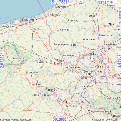
Bailleul GPS coordinates[2]
50° 44' 9.312" North, 2° 44' 9.384" East
| Map corner | latitude | longitude |
|---|---|---|
| Upper-left | 51.17881°, | 2.03282° |
| Center: | 50.73592°, | 2.73594° |
| Lower-right: | 50.2888°, | 3.43907° |
| Map W x H: | 99×99 km | = 61.5×61.5mi |
| max Lat: | 51.07786° ⇑1% North |
| Bailleul: | 50.73592° |
| min Lat: | ⇓99% South 41.3874° |
| min Long | Bailleul | max Long |
| -5.08615° | 2.73594° | 9.52242° |
| W 54%⇐ | ⇒46% E |
Elevation
Elevation of Bailleul is 34 m = 112 ft, and this is 159.7 m = 524 ft below average elevation for this country.
| Max E: |
2333 m = 7654 ft | 88.3% |
| Avg. | 193.7 m = 635 ft | |
| Bailleul | 34 m = 112 ft | |
Min E: |
-1 m = -3 ft | 11.7% |
See also: France elevation on elevation.city.
Geographical zone
Bailleul is located in North temperate zone (between Tropic of Cancer and the Arctic Circle). Distance of this North polar circle is 1759.9 km =1093.6 mi to North.| Distance of | km | miles | from Bailleul |
|---|---|---|---|
| North Pole | 4365.8 | 2712.8 | to North |
| Arctic Circle | 1759.9 | 1093.6 | to North |
| Tropic Cancer | 3035.4 | 1886.1 | to South |
| Equator | 5641.3 | 3505.3 | to South |


Nearby cities:
15 places around Bailleul: (largest is in red/bold)
• Berthen
6 km =3.7 mi,  331°
331°
• Boeschepe
7.6 km =4.7 mi,  340°
340°
• Caëstre
9.7 km =6 mi,  284°
284°
• Flêtre
6.7 km =4.2 mi,  288°
288°
• Godewaersvelde
9.1 km =5.7 mi,  315°
315°
• Le Doulieu
6.1 km =3.8 mi,  192°
192°
• Merris
5.7 km =3.5 mi,  246°
246°
• Méteren
2.5 km =1.6 mi,  263°
263°
• Neuf-Berquin
9.5 km =5.9 mi,  208°
208°
• Nieppe
7.8 km =4.8 mi,  116°
116°
• Sailly-sur-la-Lys
8.9 km =5.5 mi,  165°
165°
• Saint-Jans-Cappel
3.3 km =2.1 mi, 342°
• Steenwerck
4.8 km =3 mi,  141°
141°
• Strazeele
7.5 km =4.7 mi, 261°
• Vieux-Berquin
7.9 km =4.9 mi,  234°
234°
Sources, notices
• [Note1] Compared only with cities in France existing in our database
• [Src1] Map data: © OpenStreetMap contributors (CC-BY-SA)
• [Src2] Other city data from geonames.org with taken over terms of usage.
• [Src3] Geographical zone / Annual Mean Temperature by Robert A. Rohde @ Wikipedia
