Nieppe geodata
Nieppe (Hauts-de-France) is a populated place; located in France in Europe/Paris (GMT+2) time zone. With population of 7,638 people, there are 1267 cities with bigger population in this country. Compared to other cities in France, 98.9% of cities are located further ↓South; 55.5% of cities are located further ←West and 94.4% of cities have higher elevation than Nieppe. Note1
Administrative division(s):
- Level 1: Hauts-de-France
- Level 2: Nord
- Level 3: Arrondissement de Dunkerque
- Level 4: Nieppe


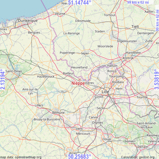
Nieppe GPS coordinates[2]
50° 42' 15.3" North, 2° 50' 6.216" East
| Map corner | latitude | longitude |
|---|---|---|
| Upper-left | 51.14744°, | 2.13194° |
| Center: | 50.70425°, | 2.83506° |
| Lower-right: | 50.25683°, | 3.53819° |
| Map W x H: | 99×99 km | = 61.5×61.5mi |
| max Lat: | 51.07786° ⇑1.1% North |
| Nieppe: | 50.70425° |
| min Lat: | ⇓98.9% South 41.3874° |
| min Long | Nieppe | max Long |
| -5.08615° | 2.83506° | 9.52242° |
| W 55.5%⇐ | ⇒44.5% E |
Elevation
Elevation of Nieppe is 19 m = 62 ft, and this is 174.7 m = 573 ft below average elevation for this country.
| Max E: |
2333 m = 7654 ft | 94.4% |
| Avg. | 193.7 m = 635 ft | |
| Nieppe | 19 m = 62 ft | |
Min E: |
-1 m = -3 ft | 5.6% |
See also: France elevation on elevation.city.
Geographical zone
Nieppe is located in North temperate zone (between Tropic of Cancer and the Arctic Circle). Distance of this North polar circle is 1763.4 km =1095.7 mi to North.| Distance of | km | miles | from Nieppe |
|---|---|---|---|
| North Pole | 4369.3 | 2715 | to North |
| Arctic Circle | 1763.4 | 1095.7 | to North |
| Tropic Cancer | 3031.9 | 1883.9 | to South |
| Equator | 5637.8 | 3503.2 | to South |


Nearby cities:
15 places around Nieppe: (largest is in red/bold)
• Armentières
3.9 km =2.4 mi,  121°
121°
• Bailleul
7.8 km =4.8 mi,  296°
296°
• Bois-Grenier
6.6 km =4.1 mi,  155°
155°
• Deûlémont
8.7 km =5.4 mi,  68°
68°
• Erquinghem-Lys
3.2 km =2 mi,  167°
167°
• Estaires
10 km =6.2 mi,  229°
229°
• Fleurbaix
6 km =3.7 mi,  181°
181°
• Frelinghien
7.1 km =4.4 mi,  78°
78°
• Houplines
5.7 km =3.5 mi,  100°
100°
• Laventie
9.6 km =6 mi,  208°
208°
• Le Doulieu
8.7 km =5.4 mi,  253°
253°
• Méteren
10 km =6.2 mi,  288°
288°
• Prémesques
9.8 km =6.1 mi, 123°
• Sailly-sur-la-Lys
6.9 km =4.3 mi,  222°
222°
• Steenwerck
4 km =2.5 mi,  266°
266°
Sources, notices
• [Note1] Compared only with cities in France existing in our database
• [Src1] Map data: © OpenStreetMap contributors (CC-BY-SA)
• [Src2] Other city data from geonames.org with taken over terms of usage.
• [Src3] Geographical zone / Annual Mean Temperature by Robert A. Rohde @ Wikipedia
