Saint-Jans-Cappel geodata
Saint-Jans-Cappel (Hauts-de-France) is a populated place; located in France in Europe/Paris (GMT+2) time zone. With population of 1,513 people, there are 6147 cities with bigger population in this country. Compared to other cities in France, 99.2% of cities are located further ↓South; 53.8% of cities are located further ←West and 89.1% of cities have higher elevation than Saint-Jans-Cappel. Note1
Administrative division(s):
- Level 1: Hauts-de-France
- Level 2: Nord
- Level 3: Arrondissement de Dunkerque
- Level 4: Saint-Jans-Cappel


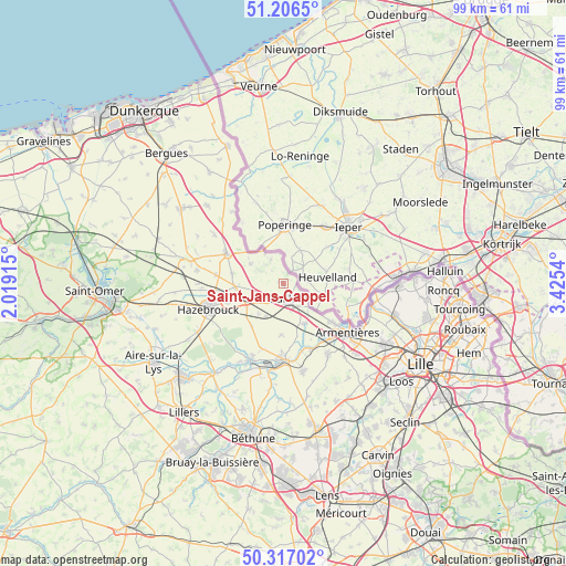
Saint-Jans-Cappel GPS coordinates[2]
50° 45' 49.932" North, 2° 43' 20.172" East
| Map corner | latitude | longitude |
|---|---|---|
| Upper-left | 51.2065°, | 2.01915° |
| Center: | 50.76387°, | 2.72227° |
| Lower-right: | 50.31702°, | 3.4254° |
| Map W x H: | 98.9×98.9 km | = 61.5×61.5mi |
| max Lat: | 51.07786° ⇑0.8% North |
| Saint-Jans-Cappel: | 50.76387° |
| min Lat: | ⇓99.2% South 41.3874° |
| min Long | Saint-Jans-Capp | max Long |
| -5.08615° | 2.72227° | 9.52242° |
| W 53.8%⇐ | ⇒46.2% E |
Elevation
Elevation of Saint-Jans-Cappel is 32 m = 105 ft, and this is 161.7 m = 531 ft below average elevation for this country.
| Max E: |
2333 m = 7654 ft | 89.1% |
| Avg. | 193.7 m = 635 ft | |
| Saint-Jans-Cappel | 32 m = 105 ft | |
Min E: |
-1 m = -3 ft | 10.9% |
See also: France elevation on elevation.city.
Geographical zone
Saint-Jans-Cappel is located in North temperate zone (between Tropic of Cancer and the Arctic Circle). Distance of this North polar circle is 1756.8 km =1091.6 mi to North.| Distance of | km | miles | from Saint-Jans-Cappel |
|---|---|---|---|
| North Pole | 4362.6 | 2710.8 | to North |
| Arctic Circle | 1756.8 | 1091.6 | to North |
| Tropic Cancer | 3038.5 | 1888 | to South |
| Equator | 5644.4 | 3507.3 | to South |


Nearby cities:
15 places around Saint-Jans-Cappel: (largest is in red/bold)
• Bailleul
3.3 km =2.1 mi,  162°
162°
• Berthen
2.9 km =1.8 mi,  318°
318°
• Boeschepe
4.3 km =2.7 mi,  338°
338°
• Borre
10.3 km =6.4 mi,  249°
249°
• Caëstre
8.4 km =5.2 mi,  265°
265°
• Eecke
9 km =5.6 mi,  280°
280°
• Flêtre
5.5 km =3.4 mi,  259°
259°
• Godewaersvelde
6.4 km =4 mi,  301°
301°
• Le Doulieu
9.1 km =5.7 mi,  182°
182°
• Merris
6.8 km =4.2 mi,  218°
218°
• Méteren
3.7 km =2.3 mi,  204°
204°
• Nieppe
10.3 km =6.4 mi,  129°
129°
• Steenwerck
7.9 km =4.9 mi,  150°
150°
• Strazeele
7.7 km =4.8 mi,  237°
237°
• Vieux-Berquin
9.4 km =5.8 mi, 215°
Sources, notices
• [Note1] Compared only with cities in France existing in our database
• [Src1] Map data: © OpenStreetMap contributors (CC-BY-SA)
• [Src2] Other city data from geonames.org with taken over terms of usage.
• [Src3] Geographical zone / Annual Mean Temperature by Robert A. Rohde @ Wikipedia
