Ayguesvives geodata
Ayguesvives (Occitanie) is a populated place; located in France in Europe/Paris (GMT+2) time zone. With population of 2,030 people, there are 4723 cities with bigger population in this country. Compared to other cities in France, 93.8% of cities are located further ↑North; 61.8% of cities are located further →East and 64.4% of cities have lower elevation than Ayguesvives. Note1
Administrative division(s):
- Level 1: Occitanie
- Level 2: Haute-Garonne
- Level 3: Arrondissement de Toulouse
- Level 4: Ayguesvives


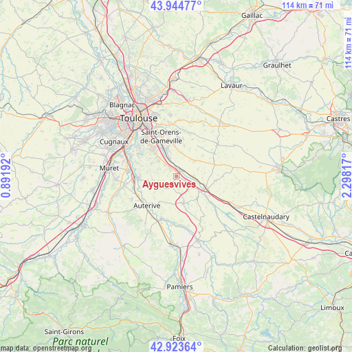
Ayguesvives GPS coordinates[2]
43° 26' 10.896" North, 1° 35' 42.18" East
| Map corner | latitude | longitude |
|---|---|---|
| Upper-left | 43.94477°, | 0.89192° |
| Center: | 43.43636°, | 1.59505° |
| Lower-right: | 42.92364°, | 2.29817° |
| Map W x H: | 113.5×113.5 km | = 70.5×70.5mi |
| max Lat: | 51.07786° ⇑93.8% North |
| Ayguesvives: | 43.43636° |
| min Lat: | ⇓6.2% South 41.3874° |
| min Long | Ayguesvives | max Long |
| -5.08615° | 1.59505° | 9.52242° |
| W 38.2%⇐ | ⇒61.8% E |
Elevation
Elevation of Ayguesvives is 191 m = 627 ft, and this is 2.7 m = 9 ft below average elevation for this country.
| Max E: |
2333 m = 7654 ft | 35.6% |
| Avg. | 193.7 m = 635 ft | |
| Ayguesvives | 191 m = 627 ft | |
Min E: |
-1 m = -3 ft | 64.4% |
See also: France elevation on elevation.city.
Geographical zone
Ayguesvives is located in North temperate zone (between Tropic of Cancer and the Arctic Circle). Distance of this Northern Tropic circle is 2223.8 km =1381.8 mi to South.| Distance of | km | miles | from Ayguesvives |
|---|---|---|---|
| North Pole | 5177.4 | 3217.1 | to North |
| Arctic Circle | 2571.5 | 1597.9 | to North |
| Tropic Cancer | 2223.8 | 1381.8 | to South |
| Equator | 4829.7 | 3001 | to South |


Nearby cities:
15 places around Ayguesvives: (largest is in red/bold)
• Baziège
2.5 km =1.6 mi,  37°
37°
• Belberaud
8 km =5 mi,  343°
343°
• Corronsac
8.9 km =5.5 mi,  297°
297°
• Deyme
7.5 km =4.7 mi,  312°
312°
• Donneville
5.4 km =3.4 mi,  315°
315°
• Fourquevaux
7.9 km =4.9 mi,  11°
11°
• Gardouch
8.7 km =5.4 mi,  125°
125°
• Labastide-Beauvoir
7.6 km =4.7 mi,  48°
48°
• Montbrun-Lauragais
6.3 km =3.9 mi,  291°
291°
• Montesquieu-Lauragais
3.5 km =2.2 mi, 128°
• Montgaillard-Lauragais
8.3 km =5.2 mi,  94°
94°
• Montgiscard
3.5 km =2.2 mi, 320°
• Montlaur
6.3 km =3.9 mi, 339°
• Saint-Léon
4.8 km =3 mi,  215°
215°
• Villenouvelle
5.5 km =3.4 mi, 90°
Sources, notices
• [Note1] Compared only with cities in France existing in our database
• [Src1] Map data: © OpenStreetMap contributors (CC-BY-SA)
• [Src2] Other city data from geonames.org with taken over terms of usage.
• [Src3] Geographical zone / Annual Mean Temperature by Robert A. Rohde @ Wikipedia
