Montlaur geodata
Montlaur (Occitanie) is a populated place; located in France in Europe/Paris (GMT+2) time zone. With population of 1,002 people, there are 8823 cities with bigger population in this country. Compared to other cities in France, 93.2% of cities are located further ↑North; 62.1% of cities are located further →East and 58% of cities have lower elevation than Montlaur. Note1
Administrative division(s):
- Level 1: Occitanie
- Level 2: Haute-Garonne
- Level 3: Arrondissement de Toulouse
- Level 4: Montlaur


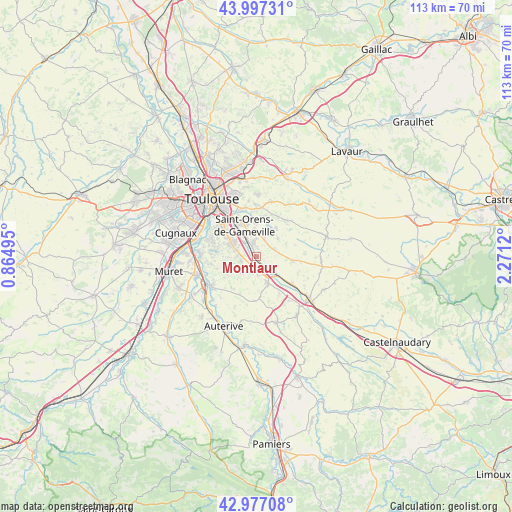
Montlaur GPS coordinates[2]
43° 29' 21.66" North, 1° 34' 5.052" East
| Map corner | latitude | longitude |
|---|---|---|
| Upper-left | 43.99731°, | 0.86495° |
| Center: | 43.48935°, | 1.56807° |
| Lower-right: | 42.97708°, | 2.2712° |
| Map W x H: | 113.4×113.4 km | = 70.5×70.5mi |
| max Lat: | 51.07786° ⇑93.2% North |
| Montlaur: | 43.48935° |
| min Lat: | ⇓6.8% South 41.3874° |
| min Long | Montlaur | max Long |
| -5.08615° | 1.56807° | 9.52242° |
| W 37.9%⇐ | ⇒62.1% E |
Elevation
Elevation of Montlaur is 161 m = 528 ft, and this is 32.7 m = 107 ft below average elevation for this country.
| Max E: |
2333 m = 7654 ft | 42% |
| Avg. | 193.7 m = 635 ft | |
| Montlaur | 161 m = 528 ft | |
Min E: |
-1 m = -3 ft | 58% |
See also: France elevation on elevation.city.
Geographical zone
Montlaur is located in North temperate zone (between Tropic of Cancer and the Arctic Circle). Distance of this Northern Tropic circle is 2229.6 km =1385.4 mi to South.| Distance of | km | miles | from Montlaur |
|---|---|---|---|
| North Pole | 5171.5 | 3213.4 | to North |
| Arctic Circle | 2565.6 | 1594.2 | to North |
| Tropic Cancer | 2229.6 | 1385.4 | to South |
| Equator | 4835.6 | 3004.7 | to South |


Nearby cities:
15 places around Montlaur: (largest is in red/bold)
• Auzielle
5.8 km =3.6 mi,  358°
358°
• Ayguesvives
6.3 km =3.9 mi,  159°
159°
• Baziège
5.4 km =3.4 mi,  136°
136°
• Belberaud
1.8 km =1.1 mi, 357°
• Corronsac
6 km =3.7 mi,  252°
252°
• Deyme
3.5 km =2.2 mi,  256°
256°
• Donneville
2.5 km =1.6 mi,  218°
218°
• Escalquens
3.2 km =2 mi,  346°
346°
• Fourquevaux
4.1 km =2.5 mi,  63°
63°
• Labège
5.2 km =3.2 mi,  330°
330°
• Montbrun-Lauragais
5.2 km =3.2 mi,  225°
225°
• Montgiscard
3.2 km =2 mi,  180°
180°
• Odars
4.1 km =2.5 mi,  24°
24°
• Pompertuzat
4.3 km =2.7 mi,  275°
275°
• Péchabou
5 km =3.1 mi,  287°
287°
Sources, notices
• [Note1] Compared only with cities in France existing in our database
• [Src1] Map data: © OpenStreetMap contributors (CC-BY-SA)
• [Src2] Other city data from geonames.org with taken over terms of usage.
• [Src3] Geographical zone / Annual Mean Temperature by Robert A. Rohde @ Wikipedia
