Ayen geodata
Ayen (Nouvelle-Aquitaine) is a populated place; located in France in Europe/Paris (GMT+2) time zone. With population of 679 people, there are 12079 cities with bigger population in this country. Compared to other cities in France, 76.9% of cities are located further ↑North; 65.3% of cities are located further →East and 81.7% of cities have lower elevation than Ayen. Note1
Administrative division(s):
- Level 1: Nouvelle-Aquitaine
- Level 2: Département de la Corrèze
- Level 3: Arrondissement de Brive-la-Gaillarde
- Level 4: Ayen


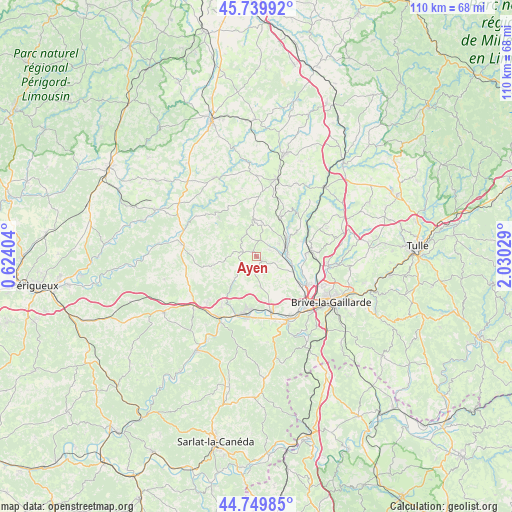
Ayen GPS coordinates[2]
45° 14' 49.344" North, 1° 19' 37.812" East
| Map corner | latitude | longitude |
|---|---|---|
| Upper-left | 45.73992°, | 0.62404° |
| Center: | 45.24704°, | 1.32717° |
| Lower-right: | 44.74985°, | 2.03029° |
| Map W x H: | 110.1×110.1 km | = 68.4×68.4mi |
| max Lat: | 51.07786° ⇑76.9% North |
| Ayen: | 45.24704° |
| min Lat: | ⇓23.1% South 41.3874° |
| min Long | Ayen | max Long |
| -5.08615° | 1.32717° | 9.52242° |
| W 34.7%⇐ | ⇒65.3% E |
Elevation
Elevation of Ayen is 308 m = 1010 ft, and this is 114.3 m = 375 ft above average elevation for this country.
| Max E: |
2333 m = 7654 ft | 18.3% |
| Ayen | 308 m 1010 ft | |
| Avg. | 193.7 m = 635 ft | |
Min E: |
-1 m = -3 ft | 81.7% |
See also: France elevation on elevation.city.
Geographical zone
Ayen is located in North temperate zone (between Tropic of Cancer and the Arctic Circle). Distance of this North polar circle is 2370.2 km =1472.8 mi to North.| Distance of | km | miles | from Ayen |
|---|---|---|---|
| North Pole | 4976.1 | 3092 | to North |
| Arctic Circle | 2370.2 | 1472.8 | to North |
| Tropic Cancer | 2425.1 | 1506.9 | to South |
| Equator | 5031 | 3126.1 | to South |


Nearby cities:
15 places around Ayen: (largest is in red/bold)
• Allassac
11.7 km =7.3 mi,  83°
83°
• Beauregard-de-Terrasson
13.4 km =8.3 mi,  214°
214°
• Brignac-la-Plaine
6.5 km =4 mi,  171°
171°
• Cublac
11.5 km =7.1 mi,  188°
188°
• Juillac
7.9 km =4.9 mi,  357°
357°
• Mansac
9.8 km =6.1 mi,  153°
153°
• Objat
6.6 km =4.1 mi,  74°
74°
• Saint-Aulaire
4 km =2.5 mi,  116°
116°
• Saint-Viance
10.4 km =6.5 mi,  108°
108°
• Salagnac
12.4 km =7.7 mi,  304°
304°
• Terrasson-Lavilledieu
13.2 km =8.2 mi, 188°
• Varetz
11.3 km =7 mi, 121°
• Vignols
9.5 km =5.9 mi,  30°
30°
• Voutezac
10 km =6.2 mi,  59°
59°
• Yssandon
5.8 km =3.6 mi,  138°
138°
Sources, notices
• [Note1] Compared only with cities in France existing in our database
• [Src1] Map data: © OpenStreetMap contributors (CC-BY-SA)
• [Src2] Other city data from geonames.org with taken over terms of usage.
• [Src3] Geographical zone / Annual Mean Temperature by Robert A. Rohde @ Wikipedia
