Objat geodata
Objat (Nouvelle-Aquitaine) is a populated place; located in France in Europe/Paris (GMT+2) time zone. With population of 3,452 people, there are 2814 cities with bigger population in this country. Compared to other cities in France, 76.7% of cities are located further ↑North; 64.2% of cities are located further →East and 51.7% of cities have higher elevation than Objat. Note1
Administrative division(s):
- Level 1: Nouvelle-Aquitaine
- Level 2: Département de la Corrèze
- Level 3: Arrondissement de Brive-la-Gaillarde
- Level 4: Objat


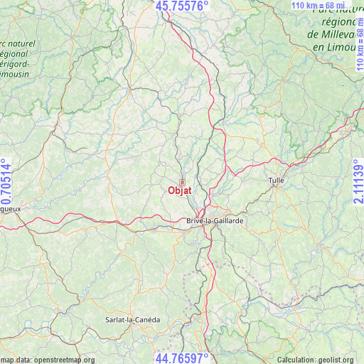
Objat GPS coordinates[2]
45° 15' 46.872" North, 1° 24' 29.736" East
| Map corner | latitude | longitude |
|---|---|---|
| Upper-left | 45.75576°, | 0.70514° |
| Center: | 45.26302°, | 1.40826° |
| Lower-right: | 44.76597°, | 2.11139° |
| Map W x H: | 110.1×110.1 km | = 68.4×68.4mi |
| max Lat: | 51.07786° ⇑76.7% North |
| Objat: | 45.26302° |
| min Lat: | ⇓23.3% South 41.3874° |
| min Long | Objat | max Long |
| -5.08615° | 1.40826° | 9.52242° |
| W 35.8%⇐ | ⇒64.2% E |
Elevation
Elevation of Objat is 126 m = 413 ft, and this is 67.7 m = 222 ft below average elevation for this country.
| Max E: |
2333 m = 7654 ft | 51.7% |
| Avg. | 193.7 m = 635 ft | |
| Objat | 126 m = 413 ft | |
Min E: |
-1 m = -3 ft | 48.3% |
See also: France elevation on elevation.city.
Geographical zone
Objat is located in North temperate zone (between Tropic of Cancer and the Arctic Circle). Distance of this North polar circle is 2368.4 km =1471.7 mi to North.| Distance of | km | miles | from Objat |
|---|---|---|---|
| North Pole | 4974.3 | 3090.9 | to North |
| Arctic Circle | 2368.4 | 1471.7 | to North |
| Tropic Cancer | 2426.9 | 1508 | to South |
| Equator | 5032.8 | 3127.2 | to South |


Nearby cities:
15 places around Objat: (largest is in red/bold)
• Allassac
5.3 km =3.3 mi,  95°
95°
• Ayen
6.6 km =4.1 mi,  254°
254°
• Beyssac
12 km =7.5 mi,  358°
358°
• Brignac-la-Plaine
9.9 km =6.2 mi,  213°
213°
• Donzenac
9.9 km =6.2 mi,  113°
113°
• Juillac
9.1 km =5.7 mi,  312°
312°
• Mansac
10.7 km =6.6 mi,  190°
190°
• Sadroc
11.2 km =7 mi,  78°
78°
• Saint-Aulaire
4.5 km =2.8 mi,  217°
217°
• Saint-Viance
6.1 km =3.8 mi,  145°
145°
• Ussac
11.3 km =7 mi,  133°
133°
• Varetz
8.4 km =5.2 mi,  156°
156°
• Vignols
6.5 km =4 mi,  347°
347°
• Voutezac
4 km =2.5 mi,  34°
34°
• Yssandon
6.6 km =4.1 mi,  202°
202°
Sources, notices
• [Note1] Compared only with cities in France existing in our database
• [Src1] Map data: © OpenStreetMap contributors (CC-BY-SA)
• [Src2] Other city data from geonames.org with taken over terms of usage.
• [Src3] Geographical zone / Annual Mean Temperature by Robert A. Rohde @ Wikipedia
