Varetz geodata
Varetz (Nouvelle-Aquitaine) is a populated place; located in France in Europe/Paris (GMT+2) time zone. With population of 1,975 people, there are 4840 cities with bigger population in this country. Compared to other cities in France, 77.5% of cities are located further ↑North; 63.6% of cities are located further →East and 59.7% of cities have higher elevation than Varetz. Note1
Administrative division(s):
- Level 1: Nouvelle-Aquitaine
- Level 2: Département de la Corrèze
- Level 3: Arrondissement de Brive-la-Gaillarde
- Level 4: Varetz


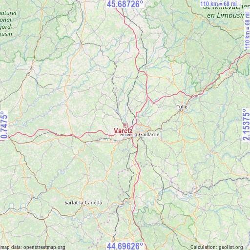
Varetz GPS coordinates[2]
45° 11' 38.112" North, 1° 27' 2.268" East
| Map corner | latitude | longitude |
|---|---|---|
| Upper-left | 45.68726°, | 0.7475° |
| Center: | 45.19392°, | 1.45063° |
| Lower-right: | 44.69626°, | 2.15375° |
| Map W x H: | 110.2×110.2 km | = 68.5×68.5mi |
| max Lat: | 51.07786° ⇑77.5% North |
| Varetz: | 45.19392° |
| min Lat: | ⇓22.5% South 41.3874° |
| min Long | Varetz | max Long |
| -5.08615° | 1.45063° | 9.52242° |
| W 36.4%⇐ | ⇒63.6% E |
Elevation
Elevation of Varetz is 103 m = 338 ft, and this is 90.7 m = 298 ft below average elevation for this country.
| Max E: |
2333 m = 7654 ft | 59.7% |
| Avg. | 193.7 m = 635 ft | |
| Varetz | 103 m = 338 ft | |
Min E: |
-1 m = -3 ft | 40.3% |
See also: France elevation on elevation.city.
Geographical zone
Varetz is located in North temperate zone (between Tropic of Cancer and the Arctic Circle). Distance of this North polar circle is 2376.1 km =1476.4 mi to North.| Distance of | km | miles | from Varetz |
|---|---|---|---|
| North Pole | 4982 | 3095.7 | to North |
| Arctic Circle | 2376.1 | 1476.4 | to North |
| Tropic Cancer | 2419.2 | 1503.2 | to South |
| Equator | 5025.1 | 3122.5 | to South |


Nearby cities:
15 places around Varetz: (largest is in red/bold)
• Allassac
7.4 km =4.6 mi,  15°
15°
• Brignac-la-Plaine
8.8 km =5.5 mi,  266°
266°
• Brive-la-Gaillarde
7.6 km =4.7 mi,  121°
121°
• Donzenac
6.8 km =4.2 mi,  57°
57°
• Larche
8.6 km =5.3 mi,  198°
198°
• Lissac-sur-Couze
10 km =6.2 mi,  175°
175°
• Malemort-sur-Corrèze
9.2 km =5.7 mi,  106°
106°
• Mansac
6 km =3.7 mi,  241°
241°
• Objat
8.4 km =5.2 mi,  336°
336°
• Pazayac
9.8 km =6.1 mi,  214°
214°
• Saint-Aulaire
7.4 km =4.6 mi,  303°
303°
• Saint-Pantaléon-de-Larche
5.9 km =3.7 mi, 183°
• Saint-Viance
2.6 km =1.6 mi,  3°
3°
• Ussac
4.9 km =3 mi,  90°
90°
• Yssandon
6 km =3.7 mi,  285°
285°
Sources, notices
• [Note1] Compared only with cities in France existing in our database
• [Src1] Map data: © OpenStreetMap contributors (CC-BY-SA)
• [Src2] Other city data from geonames.org with taken over terms of usage.
• [Src3] Geographical zone / Annual Mean Temperature by Robert A. Rohde @ Wikipedia
