Autretot geodata
Autretot (Normandy) is a populated place; located in France in Europe/Paris (GMT+2) time zone. With population of 640 people, there are 12673 cities with bigger population in this country. Compared to other cities in France, 91.1% of cities are located further ↓South; 71.2% of cities are located further →East and 54.2% of cities have lower elevation than Autretot. Note1
Administrative division(s):
- Level 1: Normandy
- Level 2: Seine-Maritime
- Level 3: Arrondissement de Rouen
- Level 4: Les Hauts-de-Caux


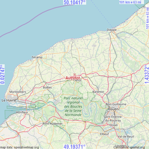
Autretot GPS coordinates[2]
49° 39' 3.852" North, 0° 43' 50.124" East
| Map corner | latitude | longitude |
|---|---|---|
| Upper-left | 50.10417°, | 0.02747° |
| Center: | 49.65107°, | 0.73059° |
| Lower-right: | 49.19371°, | 1.43372° |
| Map W x H: | 101.2×101.2 km | = 62.9×62.9mi |
| max Lat: | 51.07786° ⇑8.9% North |
| Autretot: | 49.65107° |
| min Lat: | ⇓91.1% South 41.3874° |
| min Long | Autretot | max Long |
| -5.08615° | 0.73059° | 9.52242° |
| W 28.8%⇐ | ⇒71.2% E |
Elevation
Elevation of Autretot is 147 m = 482 ft, and this is 46.7 m = 153 ft below average elevation for this country.
| Max E: |
2333 m = 7654 ft | 45.8% |
| Avg. | 193.7 m = 635 ft | |
| Autretot | 147 m = 482 ft | |
Min E: |
-1 m = -3 ft | 54.2% |
See also: France elevation on elevation.city.
Geographical zone
Autretot is located in North temperate zone (between Tropic of Cancer and the Arctic Circle). Distance of this North polar circle is 1880.5 km =1168.5 mi to North.| Distance of | km | miles | from Autretot |
|---|---|---|---|
| North Pole | 4486.4 | 2787.7 | to North |
| Arctic Circle | 1880.5 | 1168.5 | to North |
| Tropic Cancer | 2914.8 | 1811.2 | to South |
| Equator | 5520.7 | 3430.4 | to South |


Nearby cities:
15 places around Autretot: (largest is in red/bold)
• Auzebosc
6.2 km =3.9 mi,  181°
181°
• Criquetot-sur-Ouville
9 km =5.6 mi,  73°
73°
• Doudeville
8.9 km =5.5 mi,  26°
26°
• Fauville-en-Caux
10 km =6.2 mi,  270°
270°
• Hautot-Saint-Sulpice
3.5 km =2.2 mi,  14°
14°
• Héricourt-en-Caux
5.5 km =3.4 mi,  333°
333°
• Motteville
9 km =5.6 mi,  101°
101°
• Saint-Clair-sur-les-Monts
6.4 km =4 mi,  139°
139°
• Sainte-Marie-des-Champs
4.8 km =3 mi,  133°
133°
• Touffreville-la-Corbeline
8 km =5 mi,  162°
162°
• Valliquerville
5.2 km =3.2 mi,  217°
217°
• Veauville-lès-Baons
2.6 km =1.6 mi,  92°
92°
• Yvecrique
7.1 km =4.4 mi,  53°
53°
• Yvetot
4.2 km =2.6 mi,  152°
152°
• Écalles-Alix
7.6 km =4.7 mi,  119°
119°
Sources, notices
• [Note1] Compared only with cities in France existing in our database
• [Src1] Map data: © OpenStreetMap contributors (CC-BY-SA)
• [Src2] Other city data from geonames.org with taken over terms of usage.
• [Src3] Geographical zone / Annual Mean Temperature by Robert A. Rohde @ Wikipedia
