Héricourt-en-Caux geodata
Héricourt-en-Caux (Normandy) is a populated place; located in France in Europe/Paris (GMT+2) time zone. With population of 885 people, there are 9782 cities with bigger population in this country. Compared to other cities in France, 91.5% of cities are located further ↓South; 71.5% of cities are located further →East and 76.6% of cities have higher elevation than Héricourt-en-Caux. Note1
Administrative division(s):
- Level 1: Normandy
- Level 2: Seine-Maritime
- Level 3: Arrondissement de Rouen
- Level 4: Héricourt-en-Caux


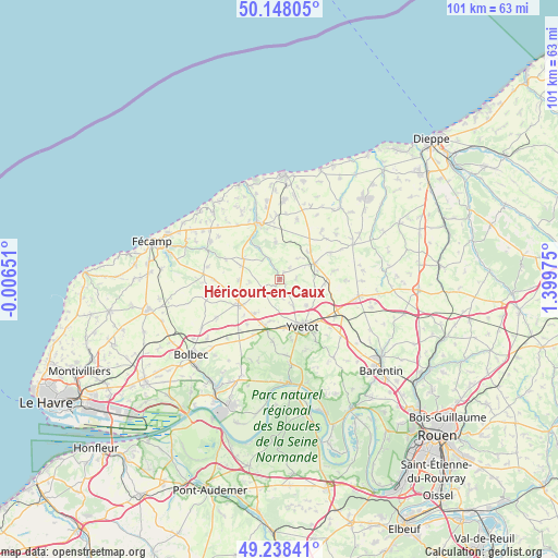
Héricourt-en-Caux GPS coordinates[2]
49° 41' 43.296" North, 0° 41' 47.832" East
| Map corner | latitude | longitude |
|---|---|---|
| Upper-left | 50.14805°, | -0.00651° |
| Center: | 49.69536°, | 0.69662° |
| Lower-right: | 49.23841°, | 1.39975° |
| Map W x H: | 101.1×101.1 km | = 62.8×62.8mi |
| max Lat: | 51.07786° ⇑8.5% North |
| Héricourt-en-Caux: | 49.69536° |
| min Lat: | ⇓91.5% South 41.3874° |
| min Long | Héricourt-en-C | max Long |
| -5.08615° | 0.69662° | 9.52242° |
| W 28.5%⇐ | ⇒71.5% E |
Elevation
Elevation of Héricourt-en-Caux is 63 m = 207 ft, and this is 130.7 m = 429 ft below average elevation for this country.
| Max E: |
2333 m = 7654 ft | 76.6% |
| Avg. | 193.7 m = 635 ft | |
| Héricourt-en-Caux | 63 m = 207 ft | |
Min E: |
-1 m = -3 ft | 23.4% |
See also: France elevation on elevation.city.
Geographical zone
Héricourt-en-Caux is located in North temperate zone (between Tropic of Cancer and the Arctic Circle). Distance of this North polar circle is 1875.6 km =1165.4 mi to North.| Distance of | km | miles | from Héricourt-en-Caux |
|---|---|---|---|
| North Pole | 4481.5 | 2784.7 | to North |
| Arctic Circle | 1875.6 | 1165.4 | to North |
| Tropic Cancer | 2919.7 | 1814.2 | to South |
| Equator | 5525.6 | 3433.4 | to South |


Nearby cities:
15 places around Héricourt-en-Caux: (largest is in red/bold)
• Autretot
5.5 km =3.4 mi,  153°
153°
• Bertheauville
9.5 km =5.9 mi,  314°
314°
• Bosville
6.7 km =4.2 mi,  354°
354°
• Cany-Barville
11.2 km =7 mi,  337°
337°
• Doudeville
7 km =4.3 mi,  64°
64°
• Fauville-en-Caux
8.9 km =5.5 mi,  237°
237°
• Grainville-la-Teinturière
7.1 km =4.4 mi,  325°
325°
• Hautot-Saint-Sulpice
3.7 km =2.3 mi,  114°
114°
• Normanville
7.4 km =4.6 mi,  269°
269°
• Ourville-en-Caux
7.6 km =4.7 mi,  299°
299°
• Sainte-Marie-des-Champs
10.2 km =6.3 mi,  144°
144°
• Valliquerville
9.1 km =5.7 mi,  184°
184°
• Veauville-lès-Baons
7.1 km =4.4 mi, 135°
• Yvecrique
8.2 km =5.1 mi,  94°
94°
• Yvetot
9.7 km =6 mi, 152°
Sources, notices
• [Note1] Compared only with cities in France existing in our database
• [Src1] Map data: © OpenStreetMap contributors (CC-BY-SA)
• [Src2] Other city data from geonames.org with taken over terms of usage.
• [Src3] Geographical zone / Annual Mean Temperature by Robert A. Rohde @ Wikipedia
