Morcenx geodata
Morcenx (Nouvelle-Aquitaine) is a populated place; located in France in Europe/Paris (GMT+2) time zone. With population of 4,993 people, there are 1986 cities with bigger population in this country. Compared to other cities in France, 86.8% of cities are located further ↑North; 87.4% of cities are located further →East and 71% of cities have higher elevation than Morcenx. Note1
Administrative division(s):
- Level 1: Nouvelle-Aquitaine
- Level 2: Landes
- Level 3: Arrondissement de Mont-de-Marsan
- Level 4: Morcenx-la-Nouvelle


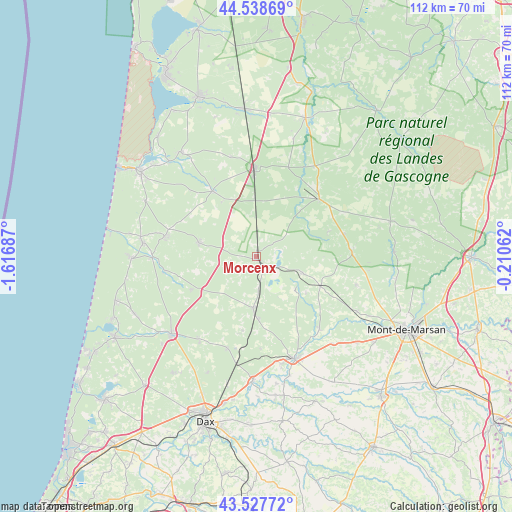
Morcenx GPS coordinates[2]
44° 2' 7.296" North, 0° 54' 49.5" West
| Map corner | latitude | longitude |
|---|---|---|
| Upper-left | 44.53869°, | -1.61687° |
| Center: | 44.03536°, | -0.91375° |
| Lower-right: | 43.52772°, | -0.21062° |
| Map W x H: | 112.4×112.4 km | = 69.8×69.8mi |
| max Lat: | 51.07786° ⇑86.8% North |
| Morcenx: | 44.03536° |
| min Lat: | ⇓13.2% South 41.3874° |
| min Long | Morcenx | max Long |
| -5.08615° | -0.91375° | 9.52242° |
| W 12.6%⇐ | ⇒87.4% E |
Elevation
Elevation of Morcenx is 76 m = 249 ft, and this is 117.7 m = 386 ft below average elevation for this country.
| Max E: |
2333 m = 7654 ft | 71% |
| Avg. | 193.7 m = 635 ft | |
| Morcenx | 76 m = 249 ft | |
Min E: |
-1 m = -3 ft | 29% |
See also: France elevation on elevation.city.
Geographical zone
Morcenx is located in North temperate zone (between Tropic of Cancer and the Arctic Circle). Distance of this Northern Tropic circle is 2290.4 km =1423.2 mi to South.| Distance of | km | miles | from Morcenx |
|---|---|---|---|
| North Pole | 5110.8 | 3175.7 | to North |
| Arctic Circle | 2504.9 | 1556.5 | to North |
| Tropic Cancer | 2290.4 | 1423.2 | to South |
| Equator | 4896.3 | 3042.4 | to South |


Nearby cities:
15 places around Morcenx: (largest is in red/bold)
• Arengosse
10.6 km =6.6 mi,  108°
108°
• Bégaar
24.1 km =15 mi,  167°
167°
• Carcen-Ponson
19 km =11.8 mi,  153°
153°
• Escource
17.2 km =10.7 mi,  326°
326°
• Geloux
22.8 km =14.2 mi, 105°
• Labouheyre
19.8 km =12.3 mi,  358°
358°
• Laluque
21.2 km =13.2 mi,  197°
197°
• Lesperon
16.1 km =10 mi,  243°
243°
• Mézos
20.5 km =12.7 mi,  282°
282°
• Onesse-Laharie
12.8 km =8 mi, 283°
• Rion-des-Landes
11.2 km =7 mi,  184°
184°
• Sabres
18.7 km =11.6 mi,  47°
47°
• Saint-Julien-en-Born
25 km =15.5 mi, 277°
• Tartas
24.1 km =15 mi,  159°
159°
• Ygos-Saint-Saturnin
15.5 km =9.6 mi, 114°
Sources, notices
• [Note1] Compared only with cities in France existing in our database
• [Src1] Map data: © OpenStreetMap contributors (CC-BY-SA)
• [Src2] Other city data from geonames.org with taken over terms of usage.
• [Src3] Geographical zone / Annual Mean Temperature by Robert A. Rohde @ Wikipedia
