Prades geodata
Prades (Auvergne-Rhône-Alpes) is a populated place; located in France in Europe/Paris (GMT+2) time zone. With population of 930 people, there are 9390 cities with bigger population in this country. Compared to other cities in France, 82.5% of cities are located further ↑North; 70.7% of cities are located further ←West and 84% of cities have lower elevation than Prades. Note1
Administrative division(s):
- Level 1: Auvergne-Rhône-Alpes
- Level 2: Département de l'Ardèche
- Level 3: Arrondissement de Largentière
- Level 4: Prades


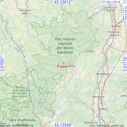
Prades GPS coordinates[2]
44° 38' 16.656" North, 4° 18' 50.508" East
| Map corner | latitude | longitude |
|---|---|---|
| Upper-left | 45.13612°, | 3.61091° |
| Center: | 44.63796°, | 4.31403° |
| Lower-right: | 44.13549°, | 5.01716° |
| Map W x H: | 111.3×111.3 km | = 69.2×69.2mi |
| max Lat: | 51.07786° ⇑82.5% North |
| Prades: | 44.63796° |
| min Lat: | ⇓17.5% South 41.3874° |
| min Long | Prades | max Long |
| -5.08615° | 4.31403° | 9.52242° |
| W 70.7%⇐ | ⇒29.3% E |
Elevation
Elevation of Prades is 334 m = 1096 ft, and this is 140.3 m = 460 ft above average elevation for this country.
| Max E: |
2333 m = 7654 ft | 16% |
| Prades | 334 m 1096 ft | |
| Avg. | 193.7 m = 635 ft | |
Min E: |
-1 m = -3 ft | 84% |
See also: France elevation on elevation.city.
Geographical zone
Prades is located in North temperate zone (between Tropic of Cancer and the Arctic Circle). Distance of this Northern Tropic circle is 2357.4 km =1464.8 mi to South.| Distance of | km | miles | from Prades |
|---|---|---|---|
| North Pole | 5043.8 | 3134.1 | to North |
| Arctic Circle | 2437.9 | 1514.8 | to North |
| Tropic Cancer | 2357.4 | 1464.8 | to South |
| Equator | 4963.3 | 3084.1 | to South |


Nearby cities:
15 places around Prades: (largest is in red/bold)
• Antraigues-sur-Volane
9.6 km =6 mi,  21°
21°
• Aubenas
6.4 km =4 mi,  108°
108°
• Jaujac
4.6 km =2.9 mi,  268°
268°
• Labégude
4.4 km =2.7 mi,  79°
79°
• Lachapelle-sous-Aubenas
9.1 km =5.7 mi,  154°
154°
• Lalevade-d’Ardèche
1.3 km =0.8 mi,  33°
33°
• Meyras
6.1 km =3.8 mi,  322°
322°
• Pont-de-Labeaume
3.7 km =2.3 mi,  328°
328°
• Saint-Didier-sous-Aubenas
8.7 km =5.4 mi, 113°
• Saint-Julien-du-Serre
8 km =5 mi,  74°
74°
• Saint-Privat
8 km =5 mi,  97°
97°
• Saint-Sernin
9.6 km =6 mi,  140°
140°
• Saint-Étienne-de-Fontbellon
7.1 km =4.4 mi,  125°
125°
• Thueyts
8.5 km =5.3 mi,  300°
300°
• Vals-les-Bains
5.1 km =3.2 mi,  53°
53°
Sources, notices
• [Note1] Compared only with cities in France existing in our database
• [Src1] Map data: © OpenStreetMap contributors (CC-BY-SA)
• [Src2] Other city data from geonames.org with taken over terms of usage.
• [Src3] Geographical zone / Annual Mean Temperature by Robert A. Rohde @ Wikipedia
