Arbois geodata
Arbois (Bourgogne-Franche-Comté) is a populated place; located in France in Europe/Paris (GMT+2) time zone. With population of 4,007 people, there are 2448 cities with bigger population in this country. Compared to other cities in France, 56.2% of cities are located further ↑North; 84.9% of cities are located further ←West and 80.6% of cities have lower elevation than Arbois. Note1
Administrative division(s):
- Level 1: Bourgogne-Franche-Comté
- Level 2: Jura
- Level 3: Arrondissement de Dole
- Level 4: Arbois


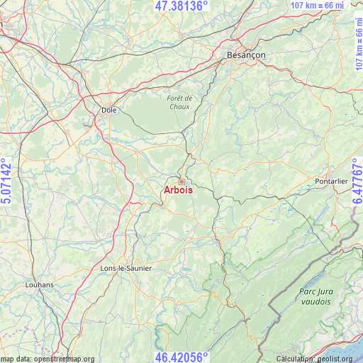
Arbois GPS coordinates[2]
46° 54' 11.196" North, 5° 46' 28.344" East
| Map corner | latitude | longitude |
|---|---|---|
| Upper-left | 47.38136°, | 5.07142° |
| Center: | 46.90311°, | 5.77454° |
| Lower-right: | 46.42056°, | 6.47767° |
| Map W x H: | 106.8×106.8 km | = 66.4×66.4mi |
| max Lat: | 51.07786° ⇑56.2% North |
| Arbois: | 46.90311° |
| min Lat: | ⇓43.8% South 41.3874° |
| min Long | Arbois | max Long |
| -5.08615° | 5.77454° | 9.52242° |
| W 84.9%⇐ | ⇒15.1% E |
Elevation
Elevation of Arbois is 297 m = 974 ft, and this is 103.3 m = 339 ft above average elevation for this country.
| Max E: |
2333 m = 7654 ft | 19.4% |
| Arbois | 297 m 974 ft | |
| Avg. | 193.7 m = 635 ft | |
Min E: |
-1 m = -3 ft | 80.6% |
See also: France elevation on elevation.city.
Geographical zone
Arbois is located in North temperate zone (between Tropic of Cancer and the Arctic Circle). Distance of this North polar circle is 2186 km =1358.3 mi to North.| Distance of | km | miles | from Arbois |
|---|---|---|---|
| North Pole | 4791.9 | 2977.5 | to North |
| Arctic Circle | 2186 | 1358.3 | to North |
| Tropic Cancer | 2609.2 | 1621.3 | to South |
| Equator | 5215.1 | 3240.5 | to South |


Nearby cities:
15 places around Arbois: (largest is in red/bold)
• Andelot-en-Montagne
13.3 km =8.3 mi,  114°
114°
• Arc-et-Senans
14.3 km =8.9 mi,  358°
358°
• Champagnole
20.6 km =12.8 mi,  149°
149°
• Crotenay
17 km =10.6 mi,  170°
170°
• Domblans
20.6 km =12.8 mi,  221°
221°
• Liesle
17.9 km =11.1 mi,  9°
9°
• Mesnay
2 km =1.2 mi,  102°
102°
• Mont-sous-Vaudrey
15.5 km =9.6 mi,  302°
302°
• Mouchard
7.9 km =4.9 mi, 12°
• Ney
20.5 km =12.7 mi,  155°
155°
• Poligny
9 km =5.6 mi, 215°
• Salins-les-Bains
9.2 km =5.7 mi,  58°
58°
• Sellières
18.1 km =11.2 mi,  242°
242°
• Voiteur
20.7 km =12.9 mi, 216°
• Équevillon
20.3 km =12.6 mi,  141°
141°
Sources, notices
• [Note1] Compared only with cities in France existing in our database
• [Src1] Map data: © OpenStreetMap contributors (CC-BY-SA)
• [Src2] Other city data from geonames.org with taken over terms of usage.
• [Src3] Geographical zone / Annual Mean Temperature by Robert A. Rohde @ Wikipedia
