Antraigues-sur-Volane geodata
Antraigues-sur-Volane (Auvergne-Rhône-Alpes) is a populated place; located in France in Europe/Paris (GMT+2) time zone. With population of 523 people, there are 14759 cities with bigger population in this country. Compared to other cities in France, 81.9% of cities are located further ↑North; 71% of cities are located further ←West and 91.5% of cities have lower elevation than Antraigues-sur-Volane. Note1
Administrative division(s):
- Level 1: Auvergne-Rhône-Alpes
- Level 2: Département de l'Ardèche
- Level 3: Arrondissement de Largentière
- Level 4: Vallées-d'Antraigues-Asperjoc
Current local time in Antraigues-sur-Volane:
11:28 AM, SaturdayDifference from your time zone: hours


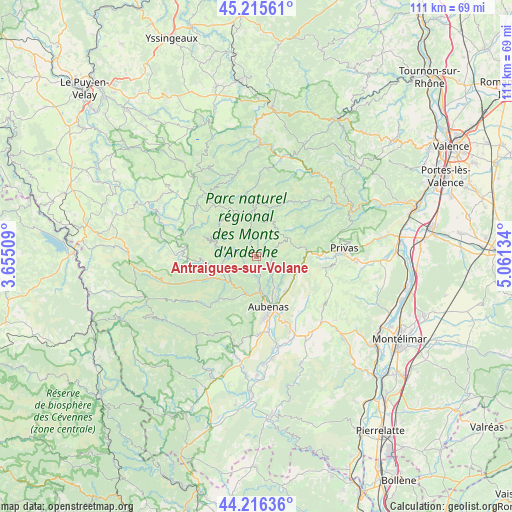
Antraigues-sur-Volane GPS coordinates[2]
44° 43' 5.304" North, 4° 21' 29.592" East
| Map corner | latitude | longitude |
|---|---|---|
| Upper-left | 45.21561°, | 3.65509° |
| Center: | 44.71814°, | 4.35822° |
| Lower-right: | 44.21636°, | 5.06134° |
| Map W x H: | 111.1×111.1 km | = 69×69mi |
| max Lat: | 51.07786° ⇑81.9% North |
| Antraigues-sur-Volane: | 44.71814° |
| min Lat: | ⇓18.1% South 41.3874° |
| min Long | Antraigues-sur- | max Long |
| -5.08615° | 4.35822° | 9.52242° |
| W 71%⇐ | ⇒29% E |
Elevation
Elevation of Antraigues-sur-Volane is 464 m = 1522 ft, and this is 270.3 m = 887 ft above average elevation for this country.
| Max E: |
2333 m = 7654 ft | 8.5% |
| Antraigues-sur-Volane | 464 m 1522 ft | |
| Avg. | 193.7 m = 635 ft | |
Min E: |
-1 m = -3 ft | 91.5% |
See also: France elevation on elevation.city.
Geographical zone
Antraigues-sur-Volane is located in North temperate zone (between Tropic of Cancer and the Arctic Circle). Distance of this Northern Tropic circle is 2366.3 km =1470.4 mi to South.| Distance of | km | miles | from Antraigues-sur-Volane |
|---|---|---|---|
| North Pole | 5034.9 | 3128.5 | to North |
| Arctic Circle | 2429 | 1509.3 | to North |
| Tropic Cancer | 2366.3 | 1470.4 | to South |
| Equator | 4972.2 | 3089.6 | to South |


Nearby cities:
15 places around Antraigues-sur-Volane: (largest is in red/bold)
• Aubenas
11.2 km =7 mi,  166°
166°
• Burzet
9.3 km =5.8 mi,  285°
285°
• Jaujac
12.1 km =7.5 mi,  221°
221°
• Labégude
8.2 km =5.1 mi, 173°
• Lalevade-d’Ardèche
8.3 km =5.2 mi,  199°
199°
• Meyras
8.3 km =5.2 mi,  240°
240°
• Montpezat-sous-Bauzon
12 km =7.5 mi,  266°
266°
• Pont-de-Labeaume
7.9 km =4.9 mi, 223°
• Prades
9.6 km =6 mi, 201°
• Saint-Didier-sous-Aubenas
13.2 km =8.2 mi,  159°
159°
• Saint-Julien-du-Serre
8 km =5 mi,  148°
148°
• Saint-Privat
10.9 km =6.8 mi, 155°
• Thueyts
11.8 km =7.3 mi,  246°
246°
• Vals-les-Bains
5.9 km =3.7 mi, 173°
• Vesseaux
9.8 km =6.1 mi,  138°
138°
Sources, notices
• [Note1] Compared only with cities in France existing in our database
• [Src1] Map data: © OpenStreetMap contributors (CC-BY-SA)
• [Src2] Other city data from geonames.org with taken over terms of usage.
• [Src3] Geographical zone / Annual Mean Temperature by Robert A. Rohde @ Wikipedia
