Caudebec-lès-Elbeuf geodata
Caudebec-lès-Elbeuf (Normandy) is a populated place; located in France in Europe/Paris (GMT+2) time zone. With population of 10,104 people, there are 940 cities with bigger population in this country. Compared to other cities in France, 85.7% of cities are located further ↓South; 68.6% of cities are located further →East and 96.7% of cities have higher elevation than Caudebec-lès-Elbeuf. Note1
Administrative division(s):
- Level 1: Normandy
- Level 2: Seine-Maritime
- Level 3: Arrondissement de Rouen
- Level 4: Caudebec-lès-Elbeuf


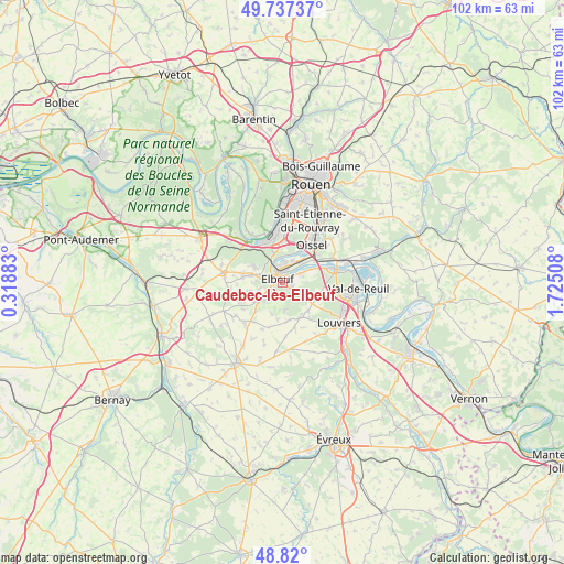
Caudebec-lès-Elbeuf GPS coordinates[2]
49° 16' 50.952" North, 1° 1' 19.02" East
| Map corner | latitude | longitude |
|---|---|---|
| Upper-left | 49.73737°, | 0.31883° |
| Center: | 49.28082°, | 1.02195° |
| Lower-right: | 48.82°, | 1.72508° |
| Map W x H: | 102×102 km | = 63.4×63.4mi |
| max Lat: | 51.07786° ⇑14.3% North |
| Caudebec-lès-Elbeuf: | 49.28082° |
| min Lat: | ⇓85.7% South 41.3874° |
| min Long | Caudebec-lès-E | max Long |
| -5.08615° | 1.02195° | 9.52242° |
| W 31.4%⇐ | ⇒68.6% E |
Elevation
Elevation of Caudebec-lès-Elbeuf is 12 m = 39 ft, and this is 181.7 m = 596 ft below average elevation for this country.
| Max E: |
2333 m = 7654 ft | 96.7% |
| Avg. | 193.7 m = 635 ft | |
| Caudebec-lès-Elbeuf | 12 m = 39 ft | |
Min E: |
-1 m = -3 ft | 3.3% |
See also: France elevation on elevation.city.
Geographical zone
Caudebec-lès-Elbeuf is located in North temperate zone (between Tropic of Cancer and the Arctic Circle). Distance of this North polar circle is 1921.7 km =1194.1 mi to North.| Distance of | km | miles | from Caudebec-lès-Elbeuf |
|---|---|---|---|
| North Pole | 4527.5 | 2813.3 | to North |
| Arctic Circle | 1921.7 | 1194.1 | to North |
| Tropic Cancer | 2873.6 | 1785.6 | to South |
| Equator | 5479.5 | 3404.8 | to South |


Nearby cities:
15 places around Caudebec-lès-Elbeuf: (largest is in red/bold)
• Cléon
3.5 km =2.2 mi,  8°
8°
• Criquebeuf-sur-Seine
6.3 km =3.9 mi,  63°
63°
• Elbeuf
1.5 km =0.9 mi,  295°
295°
• Freneuse
6 km =3.7 mi,  48°
48°
• La Haye-Malherbe
7 km =4.3 mi,  151°
151°
• La Saussaye
3.8 km =2.4 mi,  231°
231°
• Le Bosc-Roger-en-Roumois
6.4 km =4 mi,  272°
272°
• Le Thuit-Anger
3.9 km =2.4 mi,  258°
258°
• Le Thuit-Signol
6.3 km =3.9 mi,  253°
253°
• Montaure
7.1 km =4.4 mi,  137°
137°
• Saint-Aubin-lès-Elbeuf
2.7 km =1.7 mi,  341°
341°
• Saint-Didier-des-Bois
4.8 km =3 mi,  171°
171°
• Saint-Ouen-du-Tilleul
5.7 km =3.5 mi,  288°
288°
• Saint-Pierre-des-Fleurs
5.3 km =3.3 mi, 229°
• Saint-Pierre-lès-Elbeuf
1.5 km =0.9 mi,  97°
97°
Sources, notices
• [Note1] Compared only with cities in France existing in our database
• [Src1] Map data: © OpenStreetMap contributors (CC-BY-SA)
• [Src2] Other city data from geonames.org with taken over terms of usage.
• [Src3] Geographical zone / Annual Mean Temperature by Robert A. Rohde @ Wikipedia
