Allondrelle geodata
Allondrelle (Grand Est) is a populated place; located in France in Europe/Paris (GMT+2) time zone. With population of 526 people, there are 14691 cities with bigger population in this country. Compared to other cities in France, 89.4% of cities are located further ↓South; 83.4% of cities are located further ←West and 82.4% of cities have lower elevation than Allondrelle. Note1
Administrative division(s):
- Level 1: Grand Est
- Level 2: Meurthe-et-Moselle
- Level 3: Arrondissement de Briey
- Level 4: Allondrelle-la-Malmaison


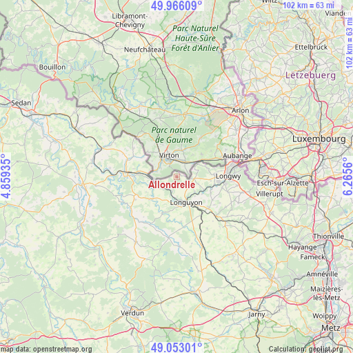
Allondrelle GPS coordinates[2]
49° 30' 42.048" North, 5° 33' 44.928" East
| Map corner | latitude | longitude |
|---|---|---|
| Upper-left | 49.96609°, | 4.85935° |
| Center: | 49.51168°, | 5.56248° |
| Lower-right: | 49.05301°, | 6.2656° |
| Map W x H: | 101.5×101.5 km | = 63.1×63.1mi |
| max Lat: | 51.07786° ⇑10.6% North |
| Allondrelle: | 49.51168° |
| min Lat: | ⇓89.4% South 41.3874° |
| min Long | Allondrelle | max Long |
| -5.08615° | 5.56248° | 9.52242° |
| W 83.4%⇐ | ⇒16.6% E |
Elevation
Elevation of Allondrelle is 315 m = 1033 ft, and this is 121.3 m = 398 ft above average elevation for this country.
| Max E: |
2333 m = 7654 ft | 17.6% |
| Allondrelle | 315 m 1033 ft | |
| Avg. | 193.7 m = 635 ft | |
Min E: |
-1 m = -3 ft | 82.4% |
See also: France elevation on elevation.city.
Geographical zone
Allondrelle is located in North temperate zone (between Tropic of Cancer and the Arctic Circle). Distance of this North polar circle is 1896 km =1178.1 mi to North.| Distance of | km | miles | from Allondrelle |
|---|---|---|---|
| North Pole | 4501.9 | 2797.4 | to North |
| Arctic Circle | 1896 | 1178.1 | to North |
| Tropic Cancer | 2899.3 | 1801.5 | to South |
| Equator | 5505.2 | 3420.8 | to South |


Nearby cities:
15 places around Allondrelle: (largest is in red/bold)
• Beuveille
12.6 km =7.8 mi,  133°
133°
• Cons-la-Grandville
10.6 km =6.6 mi,  106°
106°
• Cosnes
10.8 km =6.7 mi,  85°
85°
• Cutry
13.4 km =8.3 mi,  103°
103°
• Gorcy
9.2 km =5.7 mi,  73°
73°
• Lexy
12.2 km =7.6 mi, 96°
• Longuyon
8.4 km =5.2 mi,  158°
158°
• Marville
10.2 km =6.3 mi,  229°
229°
• Réhon
14 km =8.7 mi, 95°
• Tellancourt
5.1 km =3.2 mi, 95°
• Ugny
10.7 km =6.6 mi, 114°
• Ville-Houdlémont
7.2 km =4.5 mi,  58°
58°
• Villers-la-Chèvre
9.7 km =6 mi, 95°
• Viviers-sur-Chiers
6.7 km =4.2 mi, 129°
• Écouviez
7.6 km =4.7 mi,  284°
284°
Sources, notices
• [Note1] Compared only with cities in France existing in our database
• [Src1] Map data: © OpenStreetMap contributors (CC-BY-SA)
• [Src2] Other city data from geonames.org with taken over terms of usage.
• [Src3] Geographical zone / Annual Mean Temperature by Robert A. Rohde @ Wikipedia
