Longroy geodata
Longroy (Normandy) is a populated place; located in France in Europe/Paris (GMT+2) time zone. With population of 629 people, there are 12831 cities with bigger population in this country. Compared to other cities in France, 93.5% of cities are located further ↓South; 62.5% of cities are located further →East and 92.4% of cities have higher elevation than Longroy. Note1
Administrative division(s):
- Level 1: Normandy
- Level 2: Seine-Maritime
- Level 3: Arrondissement de Dieppe
- Level 4: Longroy


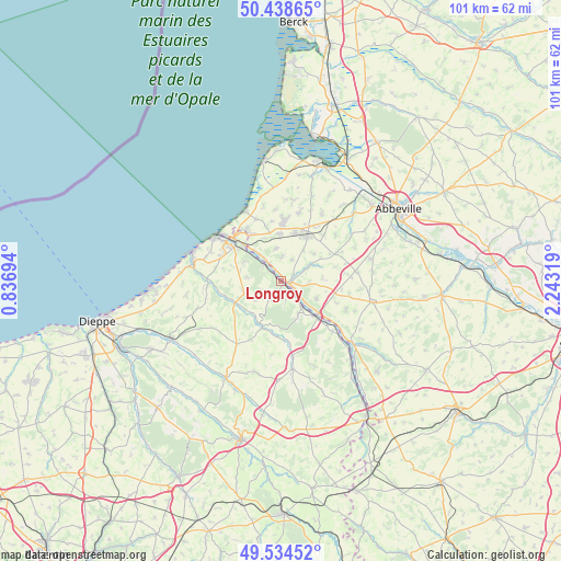
Longroy GPS coordinates[2]
49° 59' 19.356" North, 1° 32' 24.216" East
| Map corner | latitude | longitude |
|---|---|---|
| Upper-left | 50.43865°, | 0.83694° |
| Center: | 49.98871°, | 1.54006° |
| Lower-right: | 49.53452°, | 2.24319° |
| Map W x H: | 100.5×100.5 km | = 62.4×62.4mi |
| max Lat: | 51.07786° ⇑6.5% North |
| Longroy: | 49.98871° |
| min Lat: | ⇓93.5% South 41.3874° |
| min Long | Longroy | max Long |
| -5.08615° | 1.54006° | 9.52242° |
| W 37.5%⇐ | ⇒62.5% E |
Elevation
Elevation of Longroy is 24 m = 79 ft, and this is 169.7 m = 557 ft below average elevation for this country.
| Max E: |
2333 m = 7654 ft | 92.4% |
| Avg. | 193.7 m = 635 ft | |
| Longroy | 24 m = 79 ft | |
Min E: |
-1 m = -3 ft | 7.6% |
See also: France elevation on elevation.city.
Geographical zone
Longroy is located in North temperate zone (between Tropic of Cancer and the Arctic Circle). Distance of this North polar circle is 1843 km =1145.2 mi to North.| Distance of | km | miles | from Longroy |
|---|---|---|---|
| North Pole | 4448.8 | 2764.4 | to North |
| Arctic Circle | 1843 | 1145.2 | to North |
| Tropic Cancer | 2952.3 | 1834.5 | to South |
| Equator | 5558.2 | 3453.7 | to South |


Nearby cities:
15 places around Longroy: (largest is in red/bold)
• Aigneville
7.7 km =4.8 mi,  48°
48°
• Beauchamps
3 km =1.9 mi,  328°
328°
• Bouttencourt
8.8 km =5.5 mi,  130°
130°
• Bouvaincourt-sur-Bresle
5.8 km =3.6 mi,  323°
323°
• Dargnies
6 km =3.7 mi,  349°
349°
• Embreville
4.4 km =2.7 mi,  1°
1°
• Gamaches
1.2 km =0.7 mi,  103°
103°
• Incheville
4.2 km =2.6 mi,  308°
308°
• Maisnières
6.3 km =3.9 mi,  62°
62°
• Monchaux-Soreng
5.8 km =3.6 mi,  138°
138°
• Monchy-sur-Eu
6.2 km =3.9 mi,  276°
276°
• Rieux
6.6 km =4.1 mi,  152°
152°
• Saint-Pierre-en-Val
7.6 km =4.7 mi,  298°
298°
• Woincourt
8.6 km =5.3 mi,  358°
358°
• Yzengremer
8.2 km =5.1 mi, 351°
Sources, notices
• [Note1] Compared only with cities in France existing in our database
• [Src1] Map data: © OpenStreetMap contributors (CC-BY-SA)
• [Src2] Other city data from geonames.org with taken over terms of usage.
• [Src3] Geographical zone / Annual Mean Temperature by Robert A. Rohde @ Wikipedia
