Aigné geodata
Aigné (Pays de la Loire) is a populated place; located in France in Europe/Paris (GMT+2) time zone. With population of 1,411 people, there are 6559 cities with bigger population in this country. Compared to other cities in France, 60.5% of cities are located further ↓South; 77% of cities are located further →East and 74.1% of cities have higher elevation than Aigné. Note1
Administrative division(s):
- Level 1: Pays de la Loire
- Level 2: Sarthe
- Level 3: Arrondissement du Mans
- Level 4: Aigné


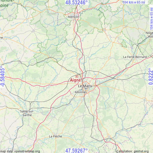
Aigné GPS coordinates[2]
48° 3' 52.956" North, 0° 7' 8.688" East
| Map corner | latitude | longitude |
|---|---|---|
| Upper-left | 48.53246°, | -0.58405° |
| Center: | 48.06471°, | 0.11908° |
| Lower-right: | 47.59267°, | 0.8222° |
| Map W x H: | 104.5×104.5 km | = 64.9×64.9mi |
| max Lat: | 51.07786° ⇑39.5% North |
| Aigné: | 48.06471° |
| min Lat: | ⇓60.5% South 41.3874° |
| min Long | Aigné | max Long |
| -5.08615° | 0.11908° | 9.52242° |
| W 23%⇐ | ⇒77% E |
Elevation
Elevation of Aigné is 69 m = 226 ft, and this is 124.7 m = 409 ft below average elevation for this country.
| Max E: |
2333 m = 7654 ft | 74.1% |
| Avg. | 193.7 m = 635 ft | |
| Aigné | 69 m = 226 ft | |
Min E: |
-1 m = -3 ft | 25.9% |
See also: France elevation on elevation.city.
Geographical zone
Aigné is located in North temperate zone (between Tropic of Cancer and the Arctic Circle). Distance of this North polar circle is 2056.9 km =1278.1 mi to North.| Distance of | km | miles | from Aigné |
|---|---|---|---|
| North Pole | 4662.8 | 2897.3 | to North |
| Arctic Circle | 2056.9 | 1278.1 | to North |
| Tropic Cancer | 2738.4 | 1701.6 | to South |
| Equator | 5344.3 | 3320.8 | to South |


Nearby cities:
15 places around Aigné: (largest is in red/bold)
• Chaufour-Notre-Dame
5.4 km =3.4 mi,  217°
217°
• Coulaines
7.8 km =4.8 mi,  125°
125°
• Degré
4.2 km =2.6 mi,  244°
244°
• Domfront-en-Champagne
8.1 km =5 mi,  303°
303°
• La Bazoge
4.5 km =2.8 mi,  36°
36°
• La Chapelle-Saint-Aubin
4.2 km =2.6 mi,  139°
139°
• La Guierche
7.9 km =4.9 mi, 44°
• La Milesse
1.1 km =0.7 mi,  98°
98°
• La Quinte
6 km =3.7 mi,  263°
263°
• Lavardin
4.4 km =2.7 mi,  287°
287°
• Neuville-sur-Sarthe
5.6 km =3.5 mi,  76°
76°
• Pruillé-le-Chétif
7.9 km =4.9 mi,  186°
186°
• Rouillon
6.6 km =4.1 mi,  169°
169°
• Saint-Saturnin
2.6 km =1.6 mi,  106°
106°
• Trangé
4.2 km =2.6 mi, 188°
Sources, notices
• [Note1] Compared only with cities in France existing in our database
• [Src1] Map data: © OpenStreetMap contributors (CC-BY-SA)
• [Src2] Other city data from geonames.org with taken over terms of usage.
• [Src3] Geographical zone / Annual Mean Temperature by Robert A. Rohde @ Wikipedia
