Neuville-sur-Sarthe geodata
Neuville-sur-Sarthe (Pays de la Loire) is a populated place; located in France in Europe/Paris (GMT+2) time zone. With population of 2,286 people, there are 4215 cities with bigger population in this country. Compared to other cities in France, 60.7% of cities are located further ↓South; 76.3% of cities are located further →East and 81.5% of cities have higher elevation than Neuville-sur-Sarthe. Note1
Administrative division(s):
- Level 1: Pays de la Loire
- Level 2: Sarthe
- Level 3: Arrondissement du Mans
- Level 4: Neuville-sur-Sarthe


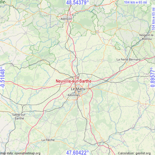
Neuville-sur-Sarthe GPS coordinates[2]
48° 4' 34.14" North, 0° 11' 33.504" East
| Map corner | latitude | longitude |
|---|---|---|
| Upper-left | 48.54379°, | -0.51048° |
| Center: | 48.07615°, | 0.19264° |
| Lower-right: | 47.60422°, | 0.89577° |
| Map W x H: | 104.5×104.5 km | = 64.9×64.9mi |
| max Lat: | 51.07786° ⇑39.3% North |
| Neuville-sur-Sarthe: | 48.07615° |
| min Lat: | ⇓60.7% South 41.3874° |
| min Long | Neuville-sur-Sa | max Long |
| -5.08615° | 0.19264° | 9.52242° |
| W 23.7%⇐ | ⇒76.3% E |
Elevation
Elevation of Neuville-sur-Sarthe is 51 m = 167 ft, and this is 142.7 m = 468 ft below average elevation for this country.
| Max E: |
2333 m = 7654 ft | 81.5% |
| Avg. | 193.7 m = 635 ft | |
| Neuville-sur-Sarthe | 51 m = 167 ft | |
Min E: |
-1 m = -3 ft | 18.5% |
See also: France elevation on elevation.city.
Geographical zone
Neuville-sur-Sarthe is located in North temperate zone (between Tropic of Cancer and the Arctic Circle). Distance of this North polar circle is 2055.6 km =1277.3 mi to North.| Distance of | km | miles | from Neuville-sur-Sarthe |
|---|---|---|---|
| North Pole | 4661.5 | 2896.5 | to North |
| Arctic Circle | 2055.6 | 1277.3 | to North |
| Tropic Cancer | 2739.6 | 1702.3 | to South |
| Equator | 5345.6 | 3321.6 | to South |


Nearby cities:
15 places around Neuville-sur-Sarthe: (largest is in red/bold)
• Aigné
5.6 km =3.5 mi,  256°
256°
• Coulaines
5.9 km =3.7 mi,  171°
171°
• La Bazoge
3.6 km =2.2 mi,  309°
309°
• La Chapelle-Saint-Aubin
5.2 km =3.2 mi,  211°
211°
• La Guierche
4.3 km =2.7 mi,  1°
1°
• La Milesse
4.6 km =2.9 mi,  251°
251°
• Lavardin
9.6 km =6 mi,  270°
270°
• Le Mans
8.5 km =5.3 mi, 173°
• Montbizot
8.2 km =5.1 mi,  355°
355°
• Rouillon
8.9 km =5.5 mi, 208°
• Saint-Saturnin
3.6 km =2.2 mi,  236°
236°
• Sainte-Jamme-sur-Sarthe
7.6 km =4.7 mi,  345°
345°
• Sargé-lès-le-Mans
5.6 km =3.5 mi,  147°
147°
• Souligné-sous-Ballon
7.5 km =4.7 mi,  25°
25°
• Trangé
8.2 km =5.1 mi,  228°
228°
Sources, notices
• [Note1] Compared only with cities in France existing in our database
• [Src1] Map data: © OpenStreetMap contributors (CC-BY-SA)
• [Src2] Other city data from geonames.org with taken over terms of usage.
• [Src3] Geographical zone / Annual Mean Temperature by Robert A. Rohde @ Wikipedia
